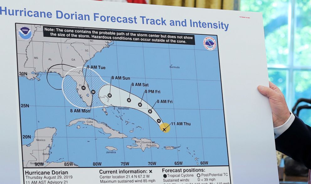
Trump displays altered weather map showing Dorian could have hit Alabama
A line showing the storm possibly hitting Alabama appeared to be drawn by hand.
After drawing criticism for inaccurately warning over the weekend that Alabama could get hit by Hurricane Dorian -- even after government meteorologists disputed that was the case -- President Donald Trump on Wednesday held up a map that appeared to have a line drawn on it in black making it seem as if he had been right all along.
In an Oval Office briefing on Dorian, Trump displayed a National Hurricane Center map from last Thursday -- which he said showed an early projection of the storm.
"This is original path that we thought -- and everybody thought that this was about a 95 percent probability," he said. "And it turned out to be not that path. It turned out to be a path going up the coast."
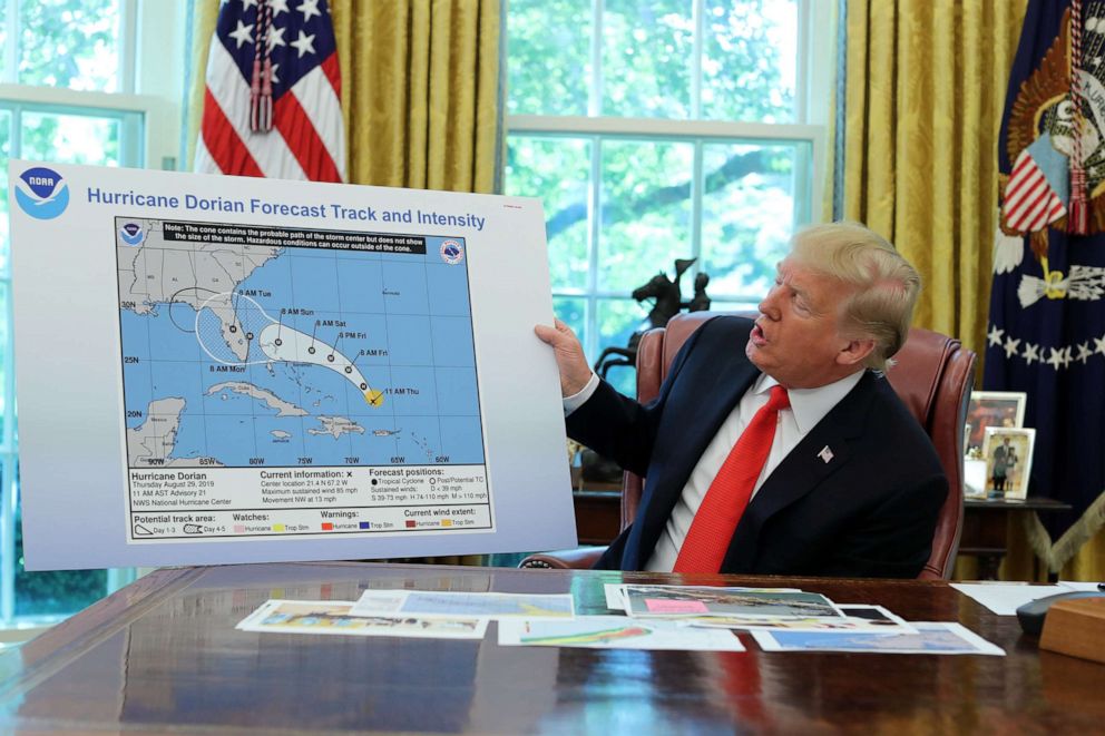
But the map he displayed had one addition not on the one disseminated by the National Hurricane Center: what appeared to be a drawn-on semicircle appended to the "cone of uncertainty" showing the hurricane's potential projected impact -- extending the cone into Alabama.
Trump on Sunday drew criticism for saying multiple times that Alabama was in the path. On Sunday morning, he tweeted, "In addition to Florida - South Carolina, North Carolina, Georgia, and Alabama, will most likely be hit (much) harder than anticipated." Soon after, the National Weather Service tweeted that was not the case. At about the same time, Trump repeated that claim to reporters at the White House, saying, "Alabama is going to get a piece of it, it looks like."
Then, that same day at the headquarters of the Federal Emergency Management Agency, Trump claimed again that Alabama could get hit.
At no point on Sunday did the government's projections show the storm impacting Alabama -- or even making landfall in Florida.
Hours after the Wednesday Dorian briefing, at a different event in the afternoon, Trump later denied knowing how or why the map had been altered when asked if he could explain how the change was made.
"No, I just know, yeah. I know that Alabama was in the original forecast," he said. "They thought it would get it, as a piece of it, it was supposed to go -- Actually we have a better map of that which is going to be presented, where we had many lines going directly -- many models, each line being a model. And they were going directly through. And in all cases, Alabama was hit. If not likely, in some cases pretty hard. Georgia and Alabama, it was a different route. They actually gave that a 95 percent chance probability," he said.
"That map that you showed us today, looked like it almost had, like, a Sharpie written on it," a reporter said during a second White House event on Wednesday.
Trump cut off the reporter and said, "I don't know. I don't know. I don't know." He also said the map had been from three or four days before, when it had actually been issued six days earlier.
White House deputy press secretary Hogan Gidley tweeted Wednesday night that the line was, in fact, from a black Sharpie, and he criticized the media for focusing on it.
Late Wednesday, Trump did tweet an additional map displaying raw data -- an "ensemble" of different computer models, and variations of those models, that meteorologists use to formulate a forecast.
"This was the originally projected path of the Hurricane in its early stages," the president wrote. "As you can see, almost all models predicted it to go through Florida also hitting Georgia and Alabama."
But the map he shared did not actually show any sort of actual projected path or official forecast -- just the raw data -- and government meteorologists never drew the conclusion that the storm would hit Alabama.
It is against federal law to knowingly issue or publish any counterfeit weather forecasts that falsely represent an official forecast issued by government entities like the National Weather Service and National Hurricane Center.
Spokespeople for the Federal Emergency Management Agency and the National Oceanic and Atmospheric Administration, which oversees the National Weather Service and the National Hurricane Center, referred questions on whether the map was doctored to the White House. The White House did not respond to multiple requests for comment.
At one point last Friday, one forecast map did show a cone that brushed the Alabama-Florida border, but it did not go nearly as far.
ABC News' Dan Peck, Mel Griffin and Matthew Vann contributed to this report.
Related Topics

Related Stories

ABC News Live