Major Heat Wave to Spread From Plains to East Coast This Week
There's a massive heat dome sitting in the center of the country.
— -- Triple digit heat index values will connect the Gulf Coast and Canada on Thursday in the middle part of the country. Sweltering heat will engulf more than half of the country in this summer’s latest heat wave. This is all due to a massive heat dome sitting in the center of the country stretching from Arizona due north to Minnesota and as far east as New York. As this heat dome, or upper level high pressure system, sits and churns over the heartland of the U.S., the air inside continues to warm and circulate oppressive heat to more than two-thirds of the country.
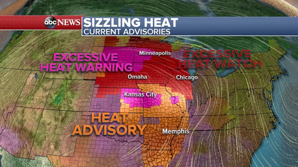
In response to this developing heat wave, the National Weather Service is preparing the affected population with advisories, watches, and warnings. Currently, there are 16 states that are under one or more of these different types of National Weather Service alerts. Heat Advisories, Excessive Heat Watches, and Excessive Heat Warnings are in effect for many cities through Friday evening from as far south as Texas and Louisiana to as far north as Minnesota and North Dakota. As this sizzling heat marches east towards the weekend, more advisories, watches, and warnings are expected to go up.
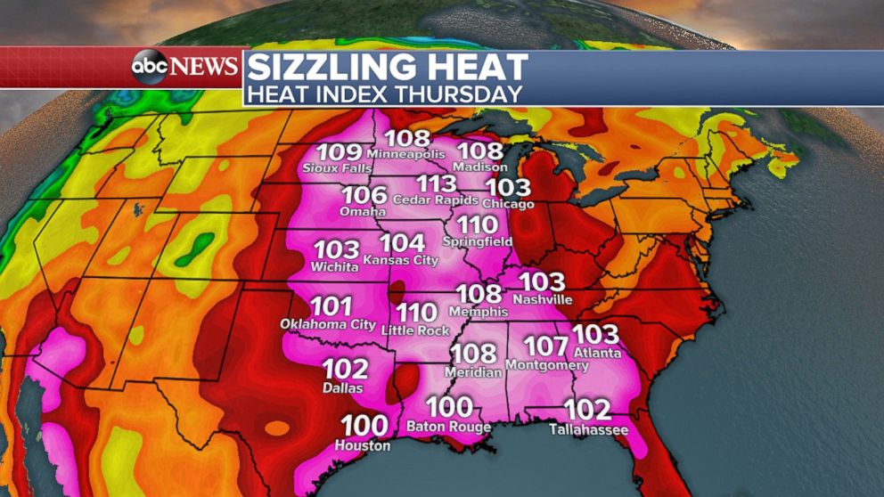
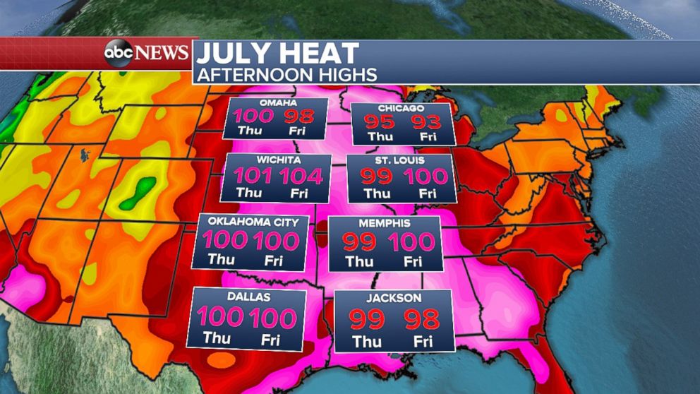
Latest computer modeling data indicates that Thursday will be the hottest day for the middle part of the country. However, as Meteorologist Paul Douglas in the Minneapolis area says quoting Yogi Berra, “'It’s not the heat, it’s the humility.' Or humidity for that matter.” Humidity coupled with high temperatures can lead to blistering heat which is exactly the scenario which will be unfolding in the area on Thursday. Heat index values in the Central Plains expanding north are expected to surpass 100 degrees and in some cities potentially over 110 degrees. Unfortunately, this heat does not leave as quickly as it comes. Friday, Minneapolis looks to get some relief with heat index values dropping from upwards of 110 to the middle 90s; the rest of the Plains remain in the 100+ heat index value range. In this part of the country, the heat sticks around through the weekend.
Looking at this event from a climatological aspect, we are currently in the hottest part of the year, therefore the weather is doing exactly what it should be! However, despite the heat being rather usual for this time of year, it is the intensity and the duration of the heat that is alarming. The Northern Plains and Midwest are expecting temperatures to be 10-20 degrees above normal with this incoming heat wave. That being said, triple digit temperatures and those within a degree or two of 100 will be the big picture here in the central part of the country on Thursday and Friday. The problem only worsens when overnight lows only dip into the middle 70s, not allowing the atmosphere to cool off. Much like the atmosphere’s way of cooling off, our body’s way of cooling off through evaporation is slowed during extreme heat. It is important to stay hydrated and avoid spending excess time outdoors.
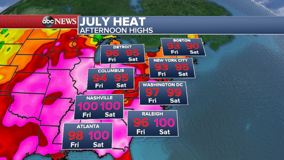
Once the peak of the heat is over in the Midwest, this impressive heat dome spreads into the Northeast and East Coast. Saturday will likely be the hottest day for the east where temperatures will be in the 90s and the heat index could approach or go above 100 degrees. Cities like Atlanta, Nashville, and Raleigh could see triple digit temperatures. To put this heat wave into perspective, many cities in the east have not seen 100 degree readings in a few years. New York City, Philadelphia, Washington, D.C., Nashville, and Atlanta haven't reached 100 degrees or above since July 2012.
The last time the Eastern part of the country had a very hot summer was in 2012. It was so unusually mild during the winter of 2011-2012 that the U.S. National Climatic Data Center called December, January and February the fourth-warmest winter for the lower 48 states since record-keeping began. Ultimately, because of the mild winter, spring and summer had an earlier start therefore allowing a faster warm up once the official start of summer began.
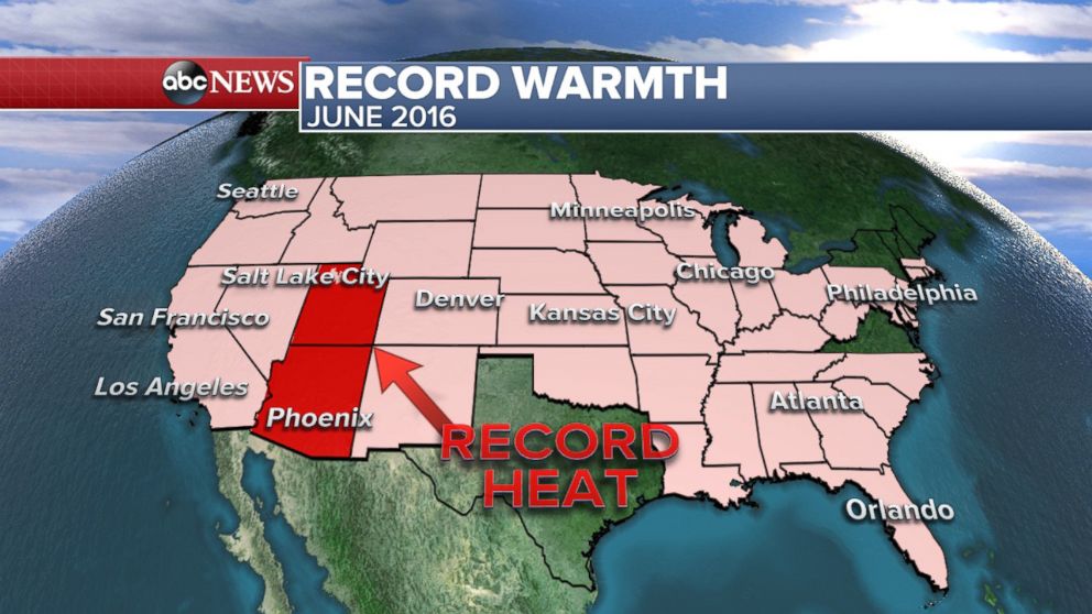
This summer already started off with record warmth for the contiguous United States. June, the first month of meteorological summer, was the warmest June on record (since 1895); it was also the warmest June for both Utah and Arizona. This is the second year in a row that June has broken this record. The average June temperature this year was 71.8 degrees, over 3 degrees higher than the 20th century average.
According to NOAA, June 2016 is also the warmest June on record for all land and ocean surfaces on the earth. This is the 14th consecutive month that the monthly global temperature record has been broken making it the longest streak since records began in 1880. The global temperatures for the first 6 months of the year was also the hottest on record.
Related Topics

Related Stories
ABC News Live