Ice Visible on Lake Superior Weeks Ahead of Schedule
For the second year in a row, ice is visible on Lake Superior in November.
— -- Cold temperatures and snow across the Great Lakes in November is certainly nothing out of the ordinary, but this morning, a layer of ice was visible on parts of Lake Superior in Ashland, Wis.
While this may not seem unusual given the current stretch of unseasonably cold temperatures, it is actually several weeks earlier than normal.
The first sightings of ice on Lake Superior and the Great Lakes overall usually occur during the beginning to middle of December. However, a perfect combination of last season's record ice coverage, cooler summer temperatures, and an early blast of arctic air this fall has allowed for areas of ice to form earlier than normal for the second year in a row.
Last winter featured relentless, record breaking cold leading to the second highest ice coverage on record for the Great Lakes as a whole.
Lake Superior also set a record for the longest length of time that ice was observed on the lake. In 2013, ice was first observed on Nov. 25, and it did not all melt until early June 2014.
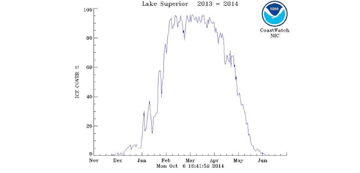
The extent and longevity of the ice coverage were both equally impressive. It is also important to note that this year the ice is being observed about 10 days earlier that last year's record-breaking season. However, an early start to ice formation does not mean another record breaking ice coverage season is on the way. The overall winter pattern over the next few months will ultimately determine where this year's ice coverage will go.
After a summer that lacked much intense heat for the region and the early arrival of long lasting arctic air, it is not taking much kick off some ice forming on Lake Superior once again.
The overall weather pattern will continue to favor below normal temperatures across the Great Lakes region for at least the next seven to 10 days -- perfect conditions to help add to the ice in place that's already setting up a wintry scene.
