Hurricane Marco, Tropical Storm Laura heading toward Gulf Coast
The last time there were two tropical cyclones in the Gulf of Mexico was 2002.
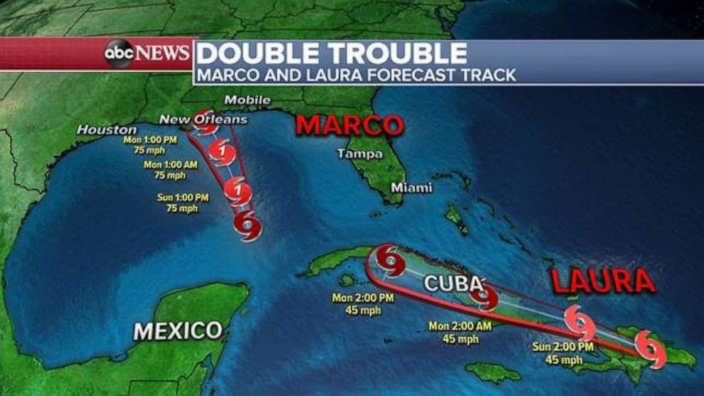
Hurricane Marco is expected to move near the Louisiana coast on Monday, followed by Tropical Storm Laura later this week, as warnings have been issued for parts of the Gulf Coast.
Marco is currently 180 miles Louisiana coast and the storm has maximum sustained winds of 75 mph -- making it a Category 1 hurricane -- while moving north-northwest at 13 mph.
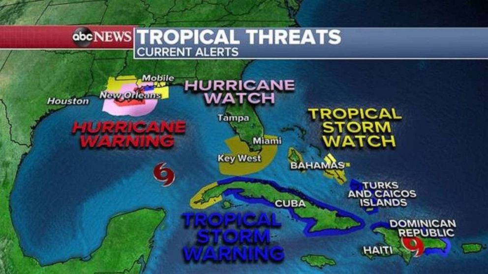
Tropical storm watches and warnings are in effect from southeastern Louisiana to the Mississippi and Alabama coastlines. Hurricane watches and warnings are also in effect along the southeast coast of Louisiana.
Cities such as New Orleans and Biloxi, Mississippi, are under a tropical storm warning and locations right along the coast are also included in the hurricane alerts.
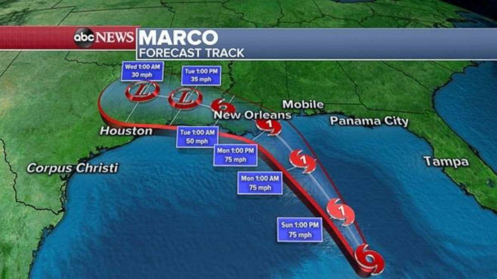
Marco is expected to gain some strength today and then quickly move into the Gulf Coast -- southeastern Louisiana remains the location where a landfall could occur and depending on the exact track that could be sometime Monday afternoon or evening.
As Marco nears the coast, atmospheric conditions will become unfavorable and begin to impact the storm. As of now, Marco could make landfall as a strong tropical storm.
As the storm nears the north central Gulf Coast on Monday, areas of rain and gusty winds will begin to impact some areas by Monday morning.
The larger impact is likely to be later Monday afternoon and evening across southeastern Louisiana and the Mississippi coast, with heavy rains, strong winds and storm surge. Some areas could see 2 to 4 inches of rain and several feet of storm surge during high tide.
Tropical Storm Laura
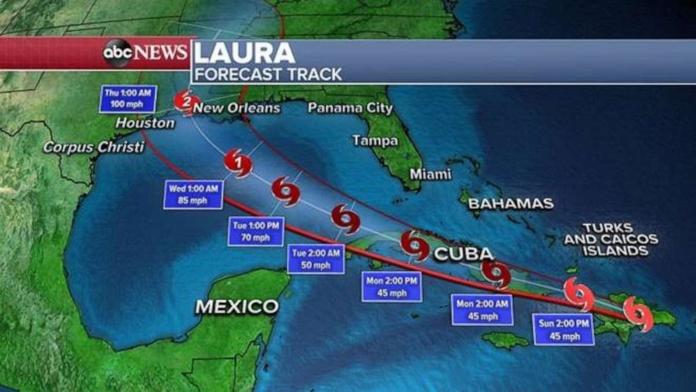
Tropical Storm Laura strengthened Sunday and now has winds of 60 mph and is moving west to northwest at 21 mph. The center of the storm is over eastern Cuba.
The storm brought life-threatening flash flooding over portions of the Dominican Republic and Haiti. At least five deaths have been registered in Haiti as a result of Tropical Storm Laura, the Haitian Civil Protection Agency said on Twitter.
There are tropical storm watches and warnings for parts of Hispaniola, Cuba, the Bahamas, and the Turks and Caicos Islands.
There is also a tropical storm watch for the Florida Keys and the waters off southern mainland Florida.
The National Hurricane Center is still forecasting that Laura will come ashore along the Gulf Coast as a Category 2 hurricane by later Wednesday and into Thursday.
Areas of potential impact
As with all tropical systems, the area to the right of the center is where the greatest impacts will occur. Right now, the center of Marco looks to be coming ashore somewhere on the Gulf Coast from southern Louisiana to southern Mississippi, with the likely region being very close to New Orleans.
Marco is expected to make landfall on Monday. When the storm comes ashore it could bring a storm surge of 2 to 6 feet, rainfall of up to 6 inches, possible tornadoes and strong winds.
Laura will move across Cuba overnight into Monday. Locally, over 8 inches of rain, strong winds and dangerous surf is expected from Hispaniola to Cuba over the next 24-30 hours. This will likely cause flash flooding and mudslides.
The official forecast track shows Laura possibly reaching the southern Gulf of Mexico as Marco is making landfall on Monday.
The forecast after this point remains somewhat uncertain. However, in forecast models, there is increasing agreement in a strengthening storm moving towards the U.S. Gulf Coast later this week.
It remains to be seen what the intensity of both storms will be and whether this situation will break any tropical records.
The last time there were two tropical cyclones in the Gulf of Mexico was in 2002, where Tropical Storm Fay was off the Texas coast and Tropical Depression Edouard was off the Florida West Coast.
The shortest time between two named storms making landfall in Louisiana was five days and that was back in 1885.
ABC News' Christine Theodorou contributed to this report.
Related Topics

Top Stories
ABC News Live