Light snow, mixed precipitation will bring messy Monday morning commute in Northeast
The start of the work week could be messy across the Northeast.
A new storm is quickly developing in the Midwest on Sunday morning, which will race off toward the Northeast and bring a snow from the Plains to New England over the next 24 to 36 hours.
There have been reports of 5 to 7 inches of snow in the Des Moines metro area as of 5 a.m. Sunday. The Iowa DOT and National Weather Service in Des Moines are reporting that parts of Interstate 35 are completely snow covered and are advising against travel due to the dangerous conditions.
Radar is showing a snow band from the Dakotas to western Indiana on Sunday morning. Some of the snow will move into parts of northern Illinois, including Chicago, later in the morning.
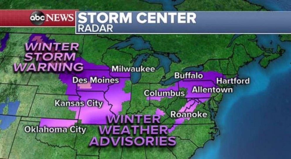
New winter weather advisories have been posted for parts of the Northeast as the storm approaches the region, which means winter weather alerts stretch from Kansas City to Boston.
During the day Sunday, snow will quickly expand east into Michigan, Ohio, Pennsylvania and western New York. As the precipitation moves toward the Interstate 95 corridor in the Northeast, it may begin as light snow before switching to mixed precipitation, especially during the first part of the overnight hours.
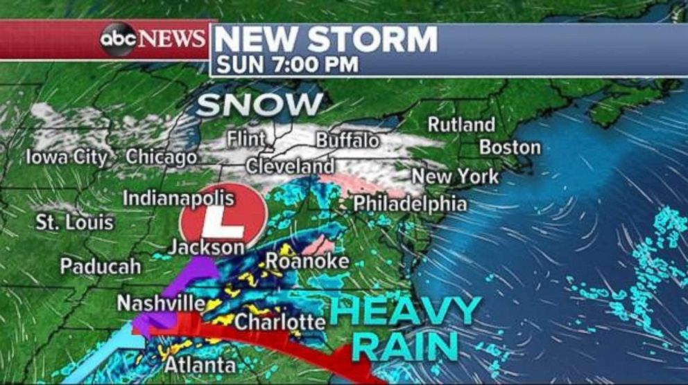
Additionally, locally heavy downpours will develop in parts of the Southeast. Rainfall totals could reach 1 to 2 inches in northern Alabama to western North Carolina. This could cause some isolated flash flooding.
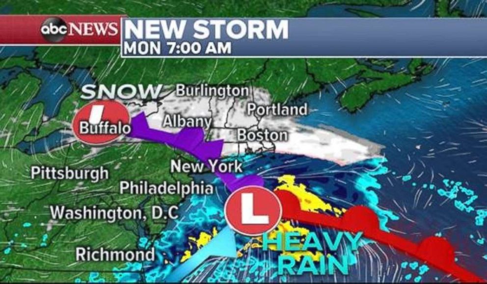
However, major cities like Philadelphia and New York are going to be on the warmer side of this storm, with snow changing to a mix, and then eventually rain during the early hours on Monday. It should remain cold enough that Albany, New York; Hartford, Connecticut; and Boston should see precipitation stay as all snow.
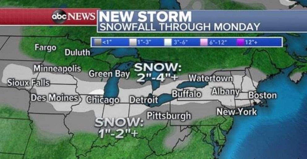
The good news is that this storm is a quick-mover. Most accumulations should be rather light, with localized amounts greater than 2 inches possible across parts of the Midwest and New England. The highest snowfall totals will likely be near the Illinois and Wisconsin border, where locally over 4 inches could be possible.
Even though snow accumulations will be light, surfaces could be slippery in the Northeast for the Monday morning commute, due to some snowfall and mixed precipitation in some of the larger cities.
Flood threat in the South
The first day of a wet pattern across the Southeast will develop on Sunday.
As a winter storm tracks quickly from the Plains to the Northeast, it will bring locally heavy rainfall from Birmingham, Alabama, to Asheville, North Carolina, later on Sunday. Rainfall totals of 1 to 2 inches are possible, which will caused localized flash flooding. Unfortunately, this same pattern will persist the entire week, with at least two more organized storms following a similar path across the central and eastern U.S.
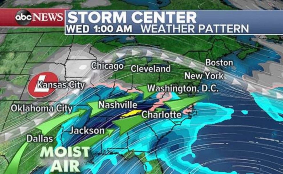
The most concerning of these storms will arrive on Tuesday and Wednesday. This storm will have potential to tap into a good deal of Gulf moisture and bring widespread heavy rain to the southeast U.S. Significant rainfall is likely across northern Mississippi and western Tennessee. The Weather Prediction Center has issued a moderate risk for flash flooding for Wednesday morning in this region.
The heaviest rain will expand eastward as the week continues due to another storm coming in right behind the Wednesday storm.
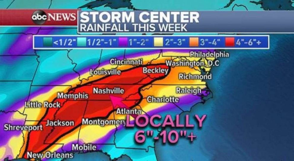
The result of this wet pattern will be rainfall totals of over 4 inches from Louisiana to West Virginia. Locally, 6 to 10 inches of rain are possible across northern Alabama, Georgia, Tennessee and Mississippi.
The risk for flash flooding will be greatest on Tuesday into Wednesday across the South due to intense rainfall rates. However, the risk for flooding, especially river flooding, will increase through the entire region as the week goes on due to increasingly saturated ground and waterways.
Related Topics
