Mild temperatures heading to the Northeast, strong winds and low humidity complicate firefighting in Calif.
High winds and low humidity complicate firefighting in Southern California.
— -- Depending on their affinity for the white stuff, residents of Upstate and western New York State found themselves in a winter wonderland Saturday, with nearly 18 inches of lake-effect snow reported in some areas.
Cattaragus County, which borders Pennsylvania in western New York state, received 17.6 inches of snow. Erie County reported 14 inches. And the city of Dunkirk issued a temporary travel advisory so it could keep up with snow removal.
For now, the threat of lake-effect snow has ended.
Looking ahead, a weak disturbance will slide into parts of the interior of the Northeast on Monday, dumping snow on an area stretching from New York to Maine during the morning hours. It does not appear that this system will result in heavy accumulation.
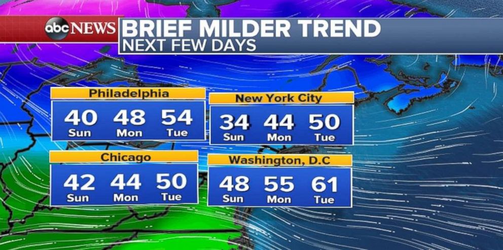
In fact, some milder weather is heading for the Northeast: Potentially into the 50s for New York City, Philadelphia, Chicago and Washington, D.C. But all good things must come to an end: This mild weather will be short-lived.
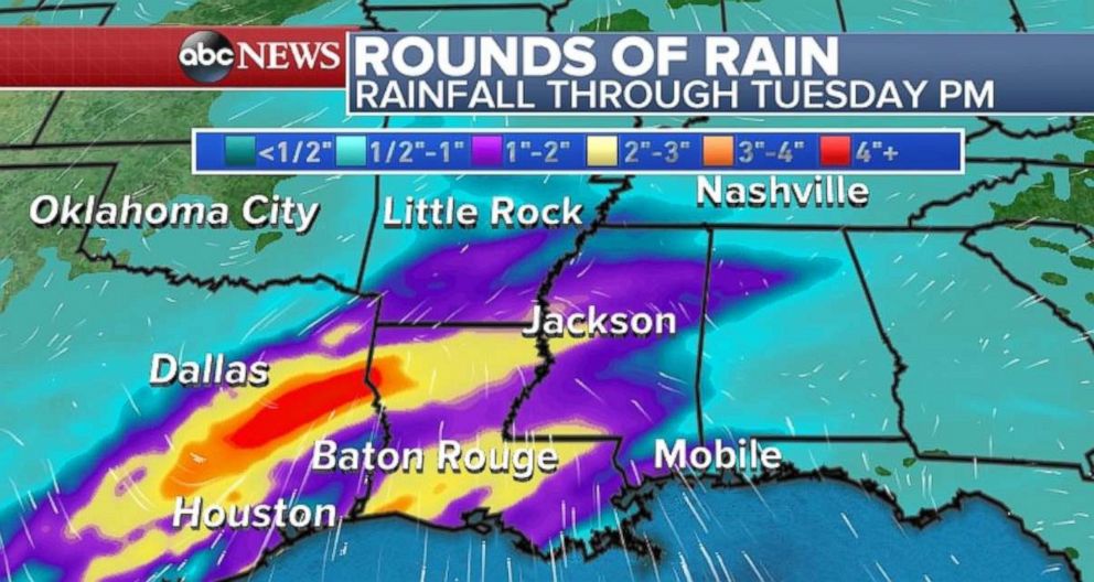
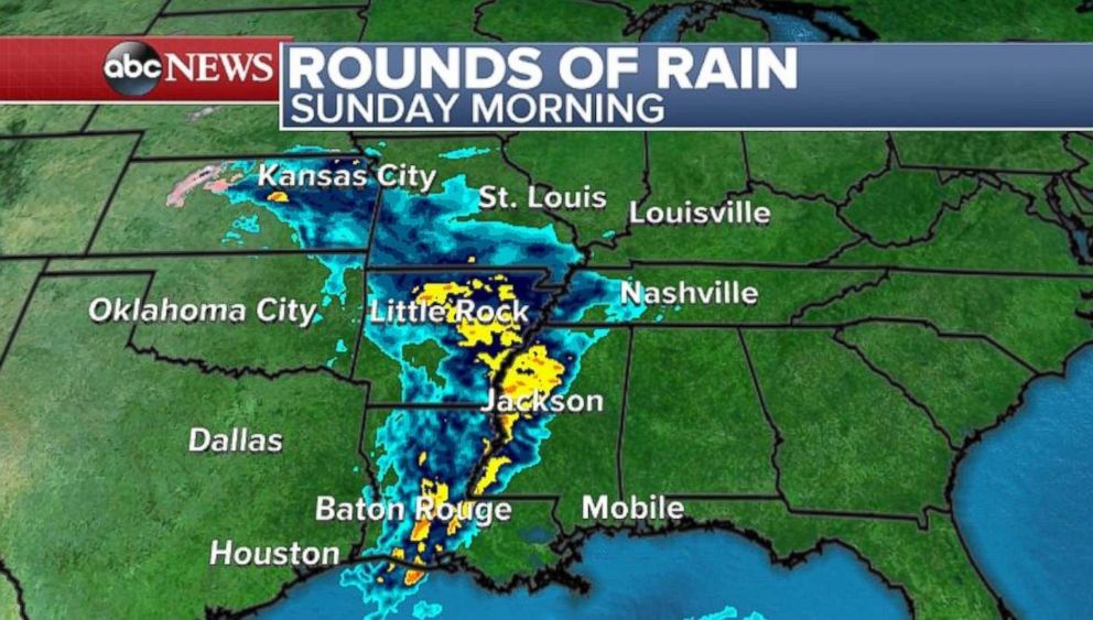
Turning to the south-central U.S., several rounds of rain are headed that region over the next few days. A round of heavy rain was moving through parts of the Gulf Coast Sunday morning. Another round of rain will move into parts of southeast Texas and southern Louisiana on Monday. A more widespread round of rain threatens to arrive on Tuesday, with heavy rain expected from Texas to Arkansas. Locally, over four inches of rain is expected over the next few days and a localized flooding threat can't be ruled out.
A potent disturbance will arrive in the Northwest and northern Rockies by Tuesday and Wednesday. Rain is expected along the Northwest coast and widespread mountain snow is expected in the northern Rockies.
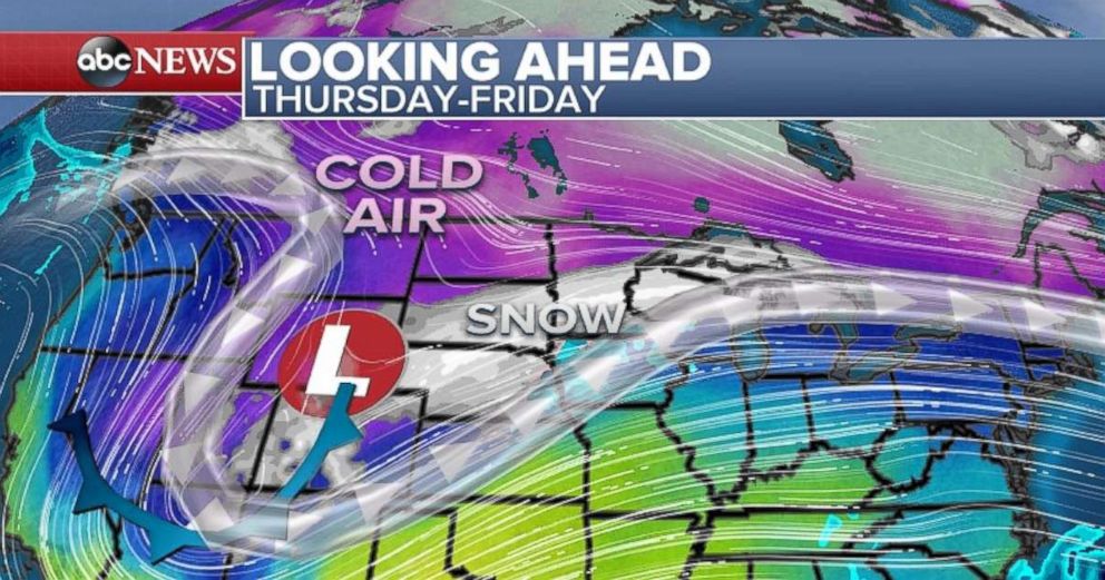
This system will reorganize and dominate the weather in the central U.S. by Thursday and Friday, which will be busy travel days. At this time, it is too early to determine the precise location and magnitude of winter weather impacts. However, it does appear that parts of the central U.S. will be impacted by winter weather at the end of this week.
Furthermore, as we head towards Christmas, it appears that the weather pattern will bring higher probabilities of below-average temperatures for much of the U.S. As this pattern sets into place, it looks like more turbulent and impactful weather will be likely as the holiday weekend approaches.
Meanwhile, on the West Coast, firefighters are feverishly battling the Thomas Fire, the third largest fire in California. The 418-square-mile (267,500 acres) blaze has destroyed more than 1,000 structures and is at 40 percent containment.
Strong winds and dry conditions are not helping the firefighting efforts.
Dry Santa Ana winds gusted to 65 mph on Saturday in Montecito, California, on Saturday. Nearly 18,000 structures are threatened in both Santa Barbara and Ventura counties. New evacuation orders were issued on Saturday for parts of Santa Barbara County, affecting between 20,000 and 25,000 residents. Officials now estimate full containment will be achieved on January 7.
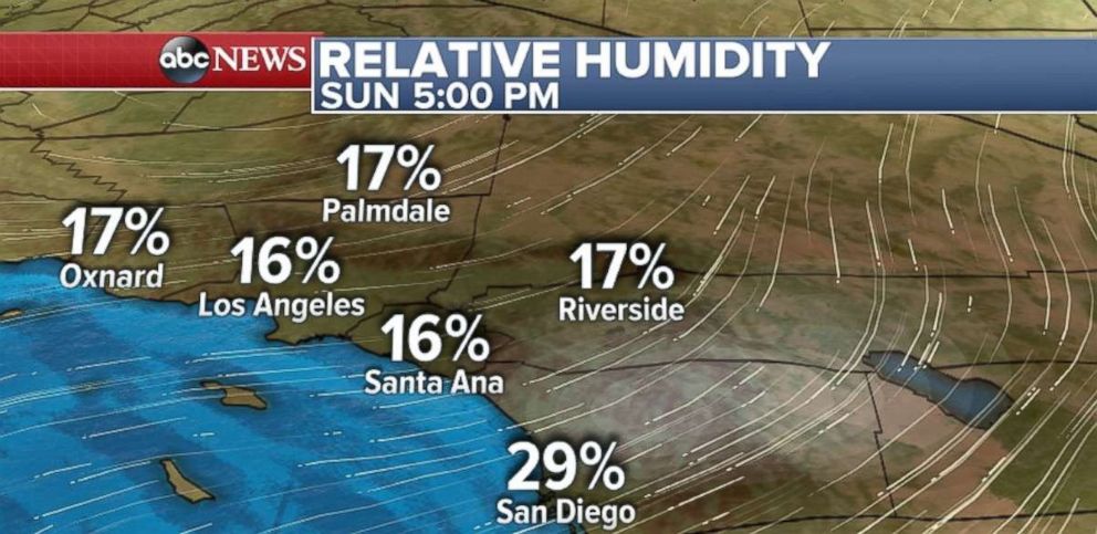

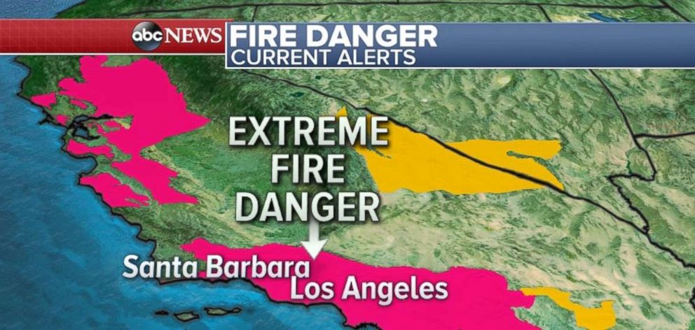
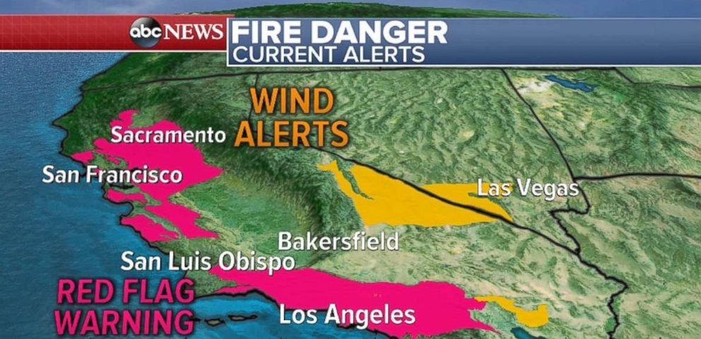
Sunday's forecast is very concerning. There's an Extreme Fire Danger warning for most of Southern California's hillsides and mountains, where winds are expected to gust as high 55 mph. The dry winds will keep relative humidity as low as 10 percent. This will lead to rapid fire growth and erratic fire behavior.
Parts of Central and Northern California are also at a critical risk for fire danger as well today, due to locally strong wind gusts and dry conditions.

Popular Reads
ABC News Live