Nor'easter winding down, coastal flooding concerns remain
The nor'easter has moved offshore, but it will remain very windy.
— -- The major nor'easter that brought intense rain, wind and snow to the Northeast on Friday is moving out to sea today.
At least 7 people are dead from the storm, and early Saturday there are still 2.3 million customers without power in 12 states across the Northeast.
Numerous roads were closed due to debris, fallen trees and power lines -- including lanes on I-95 outside of Washington, D.C. Rail service across the Northeast was impacted significantly with Amtrak suspending all service on the Northeast Corridor line.

Several communities in Massachusetts are completely in the dark Saturday morning. There were 381,000 customers without power in the state as of 6 a.m. Widespread street flooding was reported in eastern Massachusetts with storm surge reported to be as high as 3 feet. Numerous water rescues were performed, especially in Quincy, Massachusetts, where the National Guard was performing rescues into the night.
Top rainfall totals came in East Bridgewater, Massachusetts, which received 5.74 inches, while Cobleskill, New York, set the high mark with 39.3 inches of snow. Barnstable, Massachusetts, saw the highest wind gust on Friday at 93 mph, while Boston saw a 70 mph gust and New York's JFK Airport measured one at 67 mph.
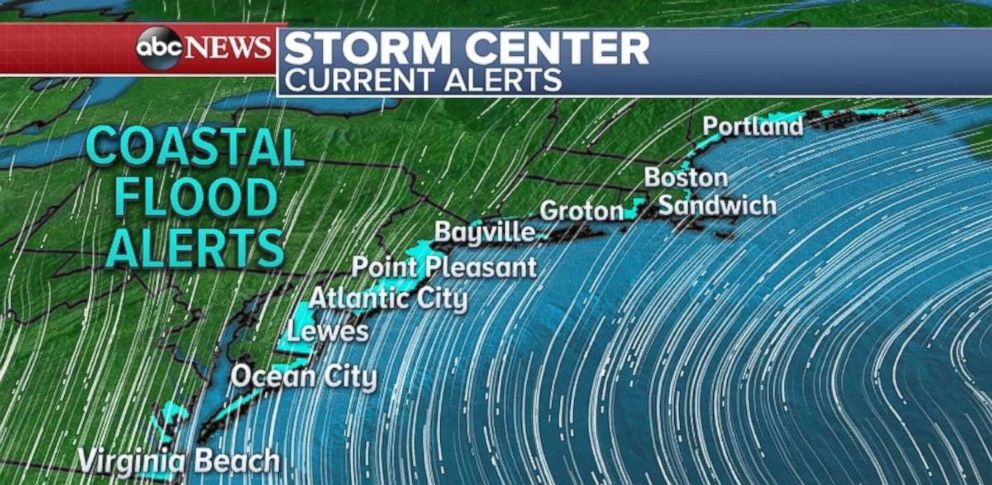
As the storm slowly pulls away, the primary concern Saturday morning is more coastal flooding from Virginia to Maine during the high-tide cycles.
The Boston Harbor rose to 14.67 feet on Friday, marking the third-highest on record there. Another high tide near 14.6 feet is forecast around noon today. Along Cape Cod, the high tide today will reach near major flood stage, and will once again be in the top-3 crests on record.
The radar and satellite Saturday morning is showing precipitation has moved offshore with only a few showers and snow bands left over the Northeast.
While the storm is several hundred miles away, wind gusts could reach 30 to 50 mph through much of the day Saturday across the northeast U.S., including all the major cities along the I-95 corridor.
The strong gusty winds will hamper recovery efforts -- especially in restoring power.
On Sunday, the storm is gone and winds will be even calmer.
Western storm dumping snow, rain
A strong storm system riding a frontal boundary is moving through the western U.S. on Saturday morning. It will bring more rain to the California coast and more snow from the Sierra Nevada Mountains to the northern Rockies.
Mammoth Mountain in California has recorded 48 inches of snow over the last three days. They could receive another foot before the storm moves out of the western U.S.
Additional snow totals of 2 to 3 feet are expected in the southern Sierra Nevada today. In Southern California, heavy rain is still possible on the hillsides. This could cause some flooding on streets. Snowfall totals up to 18 inches are expected in the highest elevations of Los Angeles and Ventura counties through Saturday.
Strong winds will move through Las Vegas today with gusts up to 65 mph.
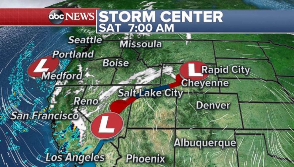
Locally 6 to 12 inches of snow is expected in the northern Rockies over the next few days. The storm will then move to the central U.S. and bring more snow to the Northern Plains and Upper Midwest, where locally over 6 inches of snow is possible on Monday.
Related Topics

Popular Reads
ABC News Live