Weather terms to know for every season, from ABC News meteorologists
From a "pineapple express" to "bombogenesis," all the major weather explained.
Ever been confused about the terms meteorologists use to describe what's happening with the weather? And just when a polar vortex finished freezing its way through town, did an Alberta Clipper come along?
For anyone who wants to know what all those weather patterns and the names used to describe them mean, here's a short glossary of common weather terms for every season.
Meteorology 101
These are common weather terms meteorologists use to describe general weather patterns during forecasts.
Cold Front: The leading edge of an advancing colder air mass. Ahead of a cold front, the air is milder and stormy, behind the cold front it is cool and drier. Severe storms, heavy rain or snow can all form along a cold front.
Warm Front: The leading edge of a warmer air mass. The air behind a warm front is warmer and moister than the air ahead of it. Fog and severe weather can be associated with warm fronts.
Stationary Front: Basically a warm or cold front that is not moving. Along a stationary front, a change in temperature and wind direction is common when crossing from one side of the front to the other. Precipitation may or may not occur along the stationary front.
Dry Line: A boundary that separates a moist air mass from a dry air mass. In the U.S., a dry line forms frequently across the Great Plains, especially in Texas, Oklahoma and Kansas where moist air from the Gulf of Mexico meets up with dry air from the Desert Southwest. This contrast can lead to severe weather outbreaks, especially in the spring months.
Dew Point: The temperature at which water droplets begin to condense and dew can form. Low dew points mean dry air, or low humidity, and high dew points mean moist air, or high humidity.
Jet Stream: A narrow bands of strong winds in the upper levels of the atmosphere. The flow is generally west to east and jet streams follow the boundary between cold and warm air masses.
Trough: An elongated region of low atmospheric pressure, which can also be a "dip" in the Jet Stream that is U-shaped. When the Jet Stream dips, it allows for colder air to move in from Canada during the winter. To the east of the trough, air is rising, which will lead to precipitation. Therefore, an active weather pattern is associated with troughs.
Ridge: An elongated region of high atmospheric pressure -- the exact opposite of a trough. Fair weather, sunny skies and warmer temperatures are associated with a ridge.
Low Pressure: A low pressure system circulates in a counter-clockwise motion forcing air upwards. Rising air causes condensation, cloud formation and precipitation. Low pressure systems can also be called storm systems since they bring inclement weather.
Coastal low: A low pressure system along the coast that can bring wind, rain, snow, flooding, waves and beach erosion.
High Pressure: A high pressure system circulates in a clockwise motion forcing air to fall. Sinking air causes fair weather and sunny skies.
Winter Weather
Winter months can bring extreme cold and snow to the eastern U.S. and heavy rain to the western U.S. Many of these winter storms and phenomena are referred to by their popular names. Here's what they mean:
Thundersnow: Thunder and lightning that occur during a snowstorm, usually associated with very heavy bands of snow.
Polar Vortex: A large area of low pressure that surrounds the Earth's poles and exists there year-round; it is a counter-clockwise circular flow of air in the upper levels that keeps the extreme cold confined to the poles. During the winter, if the flow around the polar vortex weakens, part of it can break off sending cold air southward with the jet stream and causing large arctic outbreaks in the U.S.
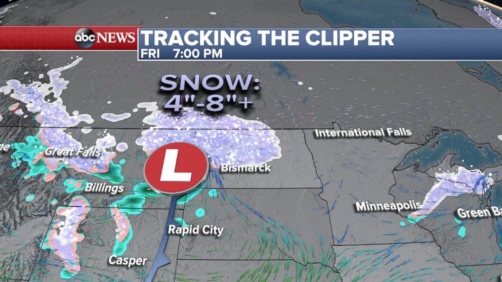
Alberta Clipper: A quick-moving low pressure system that originates from the Canadian Rockies. It brings snow, winds and cold through the Northern Plains, Midwest and Great Lakes region during the winter.
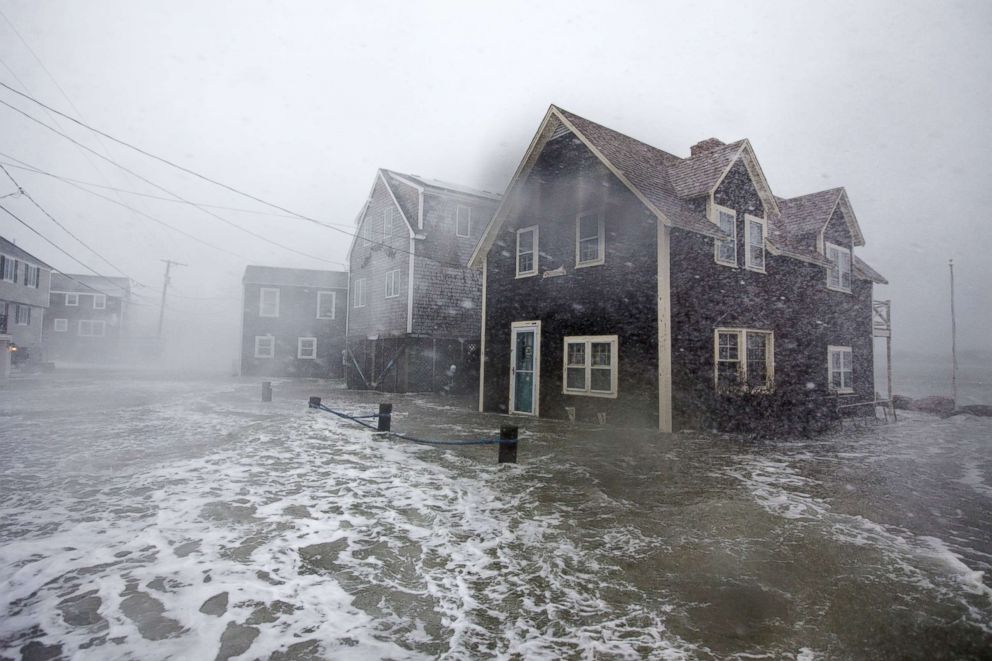
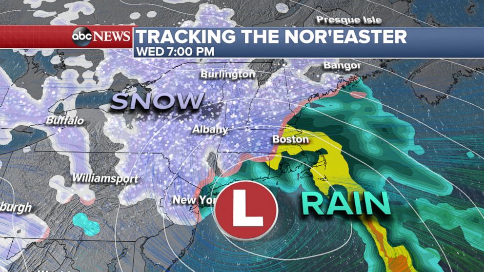
Nor'easter: A large storm along the east coast of the U.S. where winds over the coastal areas are coming from the northeast. Typically snow is involved since these storms are most frequent between September and April, but they can happen year-round. The populated I-95 corridor in the Northeast, as well as New England, get hit the most with nor'easters during the winter months. Blizzard conditions, heavy snow, high winds, coastal flooding and beach erosion are the main effects, any of which can cause significant damage.
Bombogenesis: The rapid intensification of a mid-latitude cyclone, also referred to as a "bomb cyclone." For a low pressure system to undergo bombogenensis, it must drop 24 milibars within 24 hours. The cyclone can be described as a "bomb" only because it rapidly intensified.
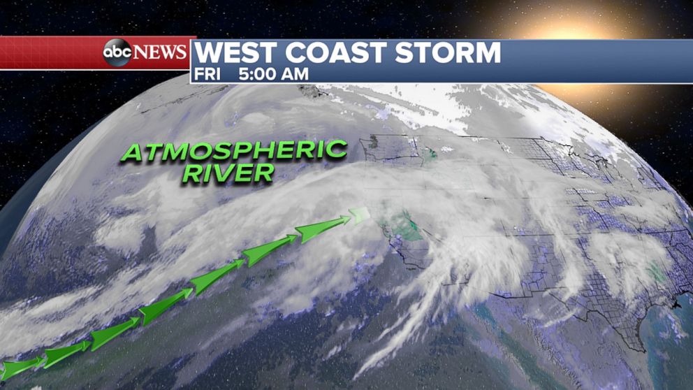
Atmospheric River: A long, narrow region, like a river, of moisture in the atmosphere that transports water vapor originating from a tropical area.
Pineapple Express: A type of atmospheric river in which the moisture is transported from the waters adjacent to the Hawaiian Islands and usually brings heavy rain to the Pacific Coasts of the U.S. and Canada.
Severe Weather
Not all weather is severe weather. To merit the term severe weather, one or more of these events has to happen: a tornado, damaging wind gusts of at least 58 mph or large hail at least 1 inch in diameter. These are some of the severe weather ingredients and common terms used during severe weather events.
Instability: An air parcel is warmer than its surrounding air at the same elevation; this means the air parcel is buoyant and can freely rise. Instability is necessary ingredient for thunderstorms.
Convection: As the sun heats the Earth, the warmer ground heats the cooler air just above it, causing that air to quickly rise, which can then cause thunderstorms if there is enough moisture. Convective thunderstorms happen frequently in the South during the spring and summer. This is why a clear sunny day is dangerous before an anticipated severe weather event –- more sun means more heat means more lift and instability in the air, which can all mean more violent storms.
Downburst: An area of strong, downward moving air from a severe thunderstorm. As the downdraft hits the ground, it is spread horizontally in all directions, resulting in severe straight-line wind damage. Downbursts can be just as dangerous and destructive as tornadoes.
Microburst: A downburst with damaging winds extending 2.5 miles or less that can last five to 15 minutes with winds up to 168 mph.
Macroburst: A downburst with damaging winds extending more than 2.5 miles that can last five to 30 minutes with winds up to 134 mph.
Straight Line Wind: This term is used to differentiate wind damage from tornado damage during a severe storm.
Derecho: A widespread and long-lived straight line wind storm, from a group of fast-moving severe thunderstorms. To be categorized as a "derecho," the swath of wind damage must extend for more than 250 miles, include wind gusts of at least 58 mph for most of its length, and include several wind gusts of at least 75 mph.
Bow Echo: Also called a "bowing line segment," this is an arched or bowed, like a bow and arrow, line of thunderstorms that are often associated with straight-line wind damage.
Squall Line: A narrow line or band of severe storms, usually along a cold front.
Supercell: A large storm cell, usually isolated, with rotating winds that can produce very large hail and tornadoes. It can also be called a rotating thunderstorm, due to the deep and persistent rotating updraft. Supercells are sometimes described as looking like "motherships" and make for impressive photographs.
M.C.S. (Mesoscale Convective System): A complex of thunderstorms that become organized on a larger scale and can persist for several hours or more.
Tornadoes
Tornadoes, which are also a severe weather event, have many specific terms. A tornado is a narrow, violently rotating vertical column of air that extends from the base of a thunderstorm to the ground. They are measured by wind speed levels and the type of damage they cause.
Reported Tornado: Any tornado before it has been confirmed by the National Weather Service. It can be reported by emergency officials, storm chasers or the general public.
Confirmed Tornado: When a survey team from local National Weather Service office goes out on location and surveys the damage, the service determines whether it was indeed a tornado and usually provides more information, such as maximum wind speeds and tornado path.
Tornado Scale: The wind speed of a tornado determines its level on the scale. EF0: 65-85 mph, EF1: 86-110 mph, EF2: 111-135 mph, EF3: 136-165 mph, EF4: 166-200 mph, EF5: Over 200 mph.
P.D.S. (Particularly Dangerous Situation): Wording used by the Storm Prediction Center and National Weather Service to signal that extremely dangerous and life-threatening weather is either occurring or expected to occur. This wording can be used to describe Tornado Watches and Warnings when the threat of strong, long-lived tornadoes is high.
Tornado Watch: Conditions are favorable for tornadoes to occur during the time period indicated.
Tornado Warning: A tornado is either imminent or occurring. It can be issued if a tornado, funnel cloud or rotation is spotted by emergency officials, storm chasers, the general public or detected on radar.
Tornado Emergency: Wording used by the National Weather Service within a Tornado Warning to alert people to take shelter immediately because a large and violent tornado is on the ground and is expected to cause significant and widespread damage.
Funnel Cloud: A rotating, funnel-shaped cloud. It can become a tornado if the funnel reaches the ground.
Waterspout: A tornado over a body of water. If it moves onto land, it can become a tornado.
Related Topics

Top Stories
ABC News Live