Weekend temperatures will be well above normal in central, eastern US
After one more cold day, temperatures will rise for the weekend.
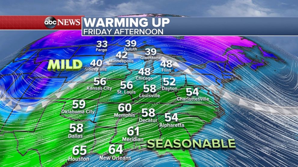
— -- The cold air is almost out of the eastern U.S. It is already a few degrees warmer Friday morning compared to yesterday.
A warmer push of air has already moved into the central U.S. with high temperatures from Kansas to Ohio about 10 to 15 degrees above average. Temperatures today in Chicago may reach nearly 50 degrees -- about 20 degrees above average. Temperatures on Friday afternoon in Minneapolis will be in the 40s -- not bad for January.
This is typically the time of the year we see brutal shots of cold air coming over the central and eastern U.S.
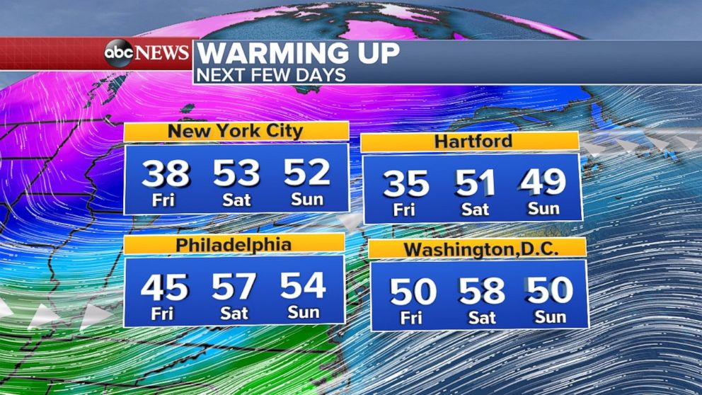
The mild weather slides eastward through the weekend. Temperatures will rise 10 to 20 degrees in the Northeast with temperatures in the 50s for the weekend.
The prolonged mild trend in the Northeast means the threat of ice jam flooding continues through the weekend. Flood watches have been posted for parts of western New Jersey and eastern Pennsylvania along the Susquehanna and Delaware rivers.
There is some forecast guidance that suggests colder weather will return to the central U.S. by early February.
Northwest storms on the way
Another round of heavy rain and snow affected parts of the Northwest on Thursday. A few strong thunderstorms developed in Northern California bringing hail and even a brief tornado warning. Near pea-sized hail fell in parts of Northern California as well.
Scattered showers and some snow will affect the region again on Friday. As we head into this weekend, another round of heavy rain moves in and lasts through Monday.
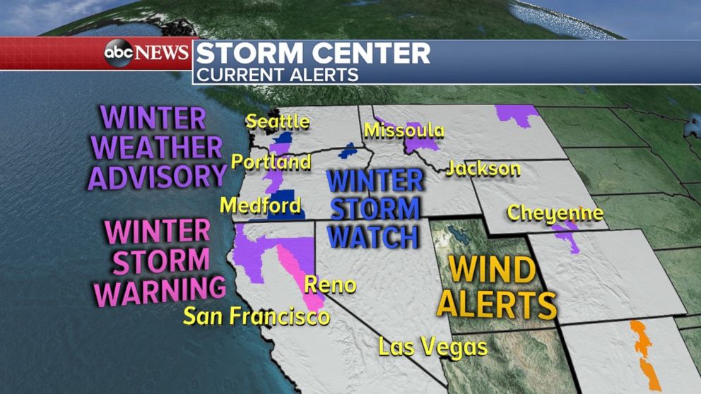
Yesterday, there was growing concern that the heaviest of the rain would head near the major I-5 metro areas. On Friday morning the forecast shows at least some of the moisture will move toward British Columbia for at least part of the weekend.
Our new rainfall forecast shows 4 to 6 inches along the immediate coast, with locally higher amounts in the Olympic and Cascade mountains. This will bring an increasing threat for landslides by the end of the weekend.
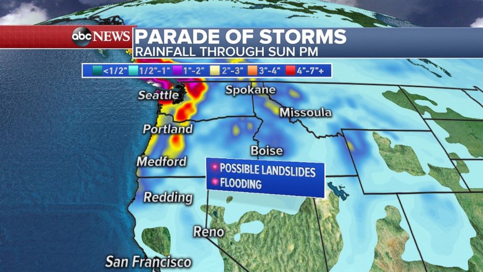
Nearly 1 to 2 feet of snow will fall in parts of the Cascades through Saturday. Locally heavy snow at times Saturday could lead to difficult driving conditions in the mountain passes. On Sunday, warmer air will increase the threat for avalanches.
Looking ahead
Outside of the Northwest storms, much of the country is rather quiet, considering this is typically a turbulent time of the year for weather.
There will be some heavy rain that moves along the Gulf Coast over the weekend. Locally 2 to 3 inches of rain will fall along the coast from Louisiana to Florida.
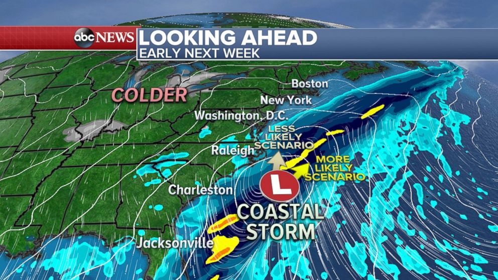
Forecast guidance is still hinting at the possibility of a coastal storm developing early next week. At this point it still appears that the storm will stay far away from the coast to limit the impacts to the eastern U.S. However, the system does warrant at least some monitoring over the next few days.
Related Topics

Popular Reads
ABC News Live