Forecasts Diverge on What Hurricane Matthew Means for US
Forecasters predict the Category 4 storm's potential path.
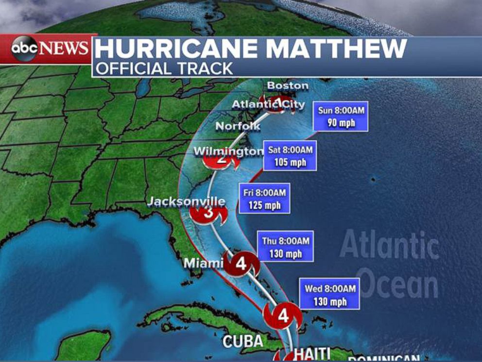
— -- The U.S. East Coast is warily bracing for the possible approach of Hurricane Matthew this week, as forecasters predict the storm will reach the United States and brush Florida by Thursday morning.
The Category 4 hurricane has brought its maximum sustained winds of 145 mph to the western tip of Cuba and is now back out in the open Caribbean Sea.
Models' forecasts differ how the storm will affect the United States in the coming days, according to ABC News meteorologist Max Golembo.
Some forecasts predict the storm will brush the Florida coast by Thursday or Friday and make landfall in the Carolinas, then move inland over the I-95 corridor from Washington, D.C., to Boston.
Other models predict Hurricane Matthew will stay farther east, missing Florida and barely hitting the Outer Banks of North Carolina and then moving out to sea. The latter prediction reflects a critical shift of about 50 miles, which could mean the difference between the eastern Florida coast's getting 130 mph winds and major storm surge and seeing just occasional gusty winds near 50 mph and some rain squalls, according to Golembo.
As of this morning, the two most reliable long-term models — the American (GFS) and European (Euro) — agree that Hurricane Matthew is likely close to making landfall in the Carolinas, but then the forecasters strongly diverge, Golembo said.
The GFS model shows the storm moving up the I-95 corridor from the mid-Atlantic to New England, while the Euro model predicts Matthew will move out to sea after affecting the Carolinas.
It is hard to say at this point which model is more accurate, according to Golembo. The Euro is generally regarded as the most reliable long-term model, and it did well predicting Super Storm Sandy's path in 2012, compared with the GFS model.
However, most other models align more closely with the GFS model's forecast, he said.
Either way, many states in the potential path of Hurricane Matthew have begun preparing for the worst.
North Carolina Gov. Pat McCrory declared a state of emergency in 66 of his counties Monday in anticipation of the storm's arrival.
"I'm hoping this is a false alarm," he said Monday, "but we can't gamble."
Florida Gov. Rick Scott also issued a state of emergency Monday as officials await Matthew's arrival.
He said that hurricane watches and warnings could be issued today, and the concern right now is from the Florida Keys to Jacksonville.
"We cannot rule out a direct hit on Florida," Scott said today, adding that a hit from the storm "could bring devastation to Florida we haven't seen in years."
"We are hoping for the best, preparing for the worst," he added.
Miami Mayor Carlos A. Gimenez said that there were no evacuation plans at this point but those living in evacuation zones should start preparing.
"The message is simple," he said today. "You should be prepared."
Popular Reads
ABC News Live
