El Nino Update and What Kind of Weather to Expect for Rest of the Winter
How the strong El Nino is expected to influence this winter's weather.

— -- The latest El Nino advisory issued by the NOAA’s Climate Prediction Center shows that the strong El Nino will continue through January and most of February and then begin to weaken later in the winter and early spring.
Mike Halpert, the Climate Prediction Center’s deputy director, said during a teleconference Thursday that El Nino effects will be felt well into spring and possibly into the up-coming summer season.
El Nino is the above-normal surface water temperatures in the equatorial Pacific Ocean. It has been influencing weather patterns around the world and the U.S. In the eastern U.S., warmer-than-normal temperatures have dominated the area in December. Also, in the West, the strong Pacific Jet Stream, influenced by El Nino, has brought more rain to Portland, San Francisco and Los Angeles than they have seen in years.
The big question is, what does the rest of the winter have in store for U.S.? To answer this question, we have to look at several other factors that affect our weather pattern in the winter months.
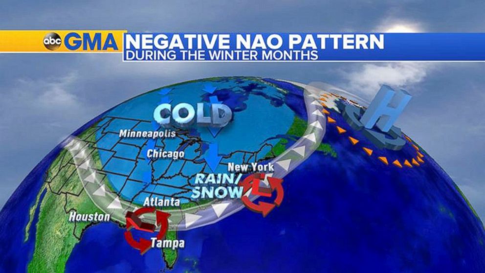
Let’s start with the Midwest and the Northeast, where a big factor is something called North American Oscillation (NAO). When NAO turns positive, like we have seen in December, it brings warmer-than-normal weather from Chicago to Atlanta to New York City. When NAO turns negative, it produces colder-than-normal weather to the eastern U.S.
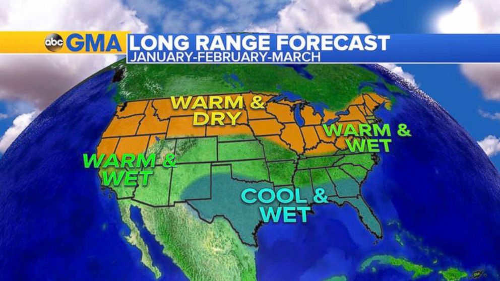
Starting with 2016, the NAO phase became negative, allowing cold air to spill south form the Arctic. As the El Nino-fueled jet stream buckled, low pressure systems riding along the jet stream have a better chance to bring snow for the major cities in the Northeast. Places like New York City, Philadelphia and Washington, D.C., have not seen measurable snowfall yet this winter. With the cold air in place and unusually active jet stream, the forecast calls for a better chance of snowfall in the next few weeks in the Northeast. Having said that, due to the dominant El Nino factor, it will be hard to hold this cold pattern in the East for too long. Moreover, long-range models consistently forecast milder-than-normal weather returning for February and March in the Midwest and the Northeast.
In the West, a persistent and extended Pacific Jet Stream fueled by El Nino is the main factor for the active weather the West Coast has been seeing in December and the first half of January.
So far, southern California and the Pacific Northwest have both seem rain, but this is unusual for El Nino winter. During a typical strong El Nino winter, the jet stream is usually split, with Polar Jet Stream riding into Alaska and Sub-Tropical jet stream riding into southern California, so most of the moisture misses the Pacific Northwest.
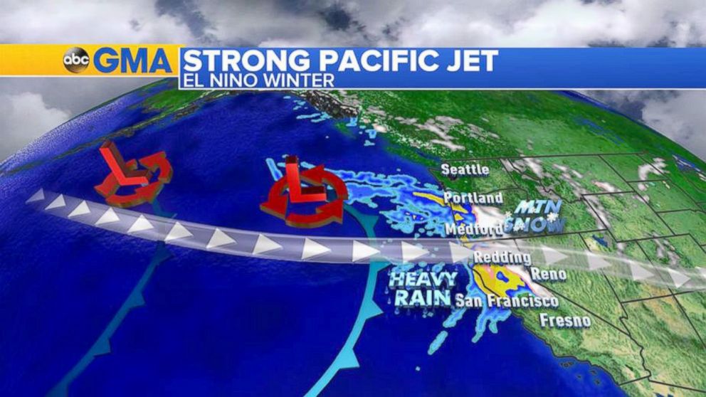
The latest water temperature readings show that the warmer-than-normal waters off the coast of Alaska are dissipating and a more typical El Nino pattern will set up in the eastern Pacific Ocean in the coming weeks.
The much-needed rainfall is expected to return to southern California by the end of January and into February.
As Mike Halpert said during the teleconference, there are many factors that influence the weather pattern in the U.S., and El Nino is just one of them. The warming climate in the past 30 to 40 years also adds to the forecast.
Warmer atmosphere can hold more moisture, resulting in heavier rain and snow storms and more intense severe weather outbreaks, he said. This could also affect the jet stream, and move the storm track further south or further north, and that’s already been happening on the West Coast.

Popular Reads
ABC News Live