Gonzalo Strengthens to Major Hurricane, Takes Aim at Bermuda
Tropical Storm Ana could hit the Hawaiian Islands by this weekend.
— -- Gonzalo was a major hurricane this morning with winds of 125 mph, and it was strengthening on an expected path to hit Bermuda Friday.
If Gonzalo becomes a Category 4 hurricane, with winds of 140 mph, it would be the strongest hurricane in Atlantic Ocean since Oct. 2, 2011, when Hurricane Ophelia's winds reached 140 mph.
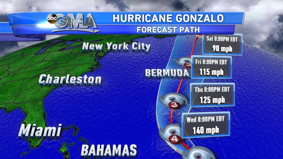
The current forecast would take Gonzalo over Bermuda Friday midday as possibly a major hurricane with winds around 115 mph. A hurricane watch has been posted for Bermuda.
Earlier this week, on Monday, Gonzalo passed over the islands of the Lesser Antilles, with Antigua Island recording sustained winds of sustained winds of 67 mph, gusting to 88 mph; Barbuda recording sustained winds of 60 mph, gusting to 70 mph; and St. Martin recording sustained winds of 63 mph, gusting to 75 mph Monday evening. A personal weather station on St. Barthelemy recorded sustained winds of 82 mph, gusting to 108 mph.
The storm intensified most of the day Tuesday and stayed over open water.
Today, Gonzalo was expected to keep growing and could reach Category 4 strength, with winds 140 mph.
Meanwhile, Tropical Storm Ana was headed toward Hawaii with sustained winds of 70 mph. It was forecast to become a hurricane later this morning and head for the Hawaiian Islands just in time for the weekend.
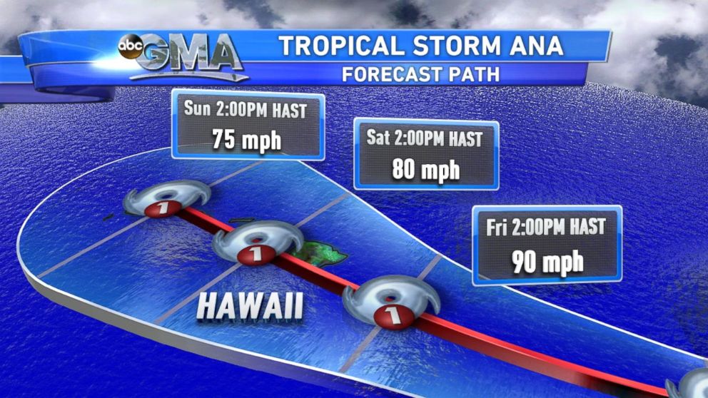
If Ana makes landfall on the big island of Hawaii as a hurricane, it would be the first time a hurricane ever made landfall in Hawaii.
In August, Iselle made landfall on the big island as a tropical storm, and if Ana were to do the same, it would be the first time in recorded history that two tropical storms made landfall in Hawaii in a single season.

Popular Reads
ABC News Live