Matthew Weakens Slightly to a Category 4 Hurricane With Jamaica in Its Path
It was briefly a Category 5 hurricane during the early hours of Saturday.
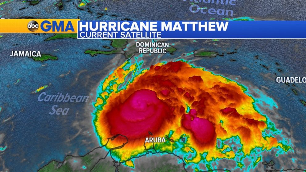
— -- Hurricane Matthew continues to be unpredictable: At 10:57 p.m. on Friday, the National Hurricane Center announced Matthew had strengthened from a Category 4 to a Category 5 hurricane over the Caribbean Sea with maximum sustained winds up to 160 mph.
But less than six hours later, at 4:45 a.m on Saturday, the NHC announced Matthew had weakened and returned to a Category 4 hurricane.
Although Matthew has officially weakened, ABC News meteorologist Daniel Manzo says its current maximum sustained winds are up to 155 mph -- a decrease of only 5 mph from late Friday night. Plus, it continues to move westward at 7 mph, as it was earlier.
"Matthew is still a really powerful and dangerous storm." Manzo says. "Regardless whether the storm is a strong category 4 or a weak Category 5, the storm is very well organized, very intense and has the potential to bring major impacts to parts of the Caribbean early next week"
Prior to slightly weakening, Matthew had been the strongest hurricane in the Atlantic since Hurricane Felix in 2007, according to the NHC. It is also the second major hurricane in the Atlantic Basin in 2016.
As of Friday at 11 p.m. ET, Matthew was centered about 80 miles northwest of Punta Gallinas, Colombia, and about 440 miles southeast of Kingston, Jamaica.
Matthew is expected to hit eastern Jamaica on Monday. But Evan Thompson, director of the National Meteorological Service, told The Associated Press that the first effects of Matthew may be felt as early as Saturday.
"We do consider it serious," he said. "We are all on high alert."
A hurricane watch has been issued for Jamaica, and rainfall totals of 10 to 15 inches with maximum sustained amounts of 25 inches are expected across Jamaica and southern and southwestern Haiti.
The U.S. embassy in Kingston announced Friday that its consular services section will be closed on Monday and Tuesday in anticipation of Matthew.
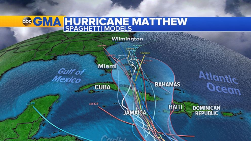
The hurricane is on path to travel west-by-southwest through the central Caribbean on Friday afternoon and to retain its strength as a major hurricane, the National Hurricane Center showed.
By early Sunday morning, Matthew is forecast to begin to turn north toward Jamaica.
After it is expected to hit Jamaica on Monday, the eastern part of Cuba could see a direct hit later that evening from Matthew with damaging winds, flooding rain and large waves.
"As Matthew moves over Cuba it will lose some strength due to the friction with the land mass," ABC News meteorologist Max Golembo said. "As it re-emerges north of Cuba in the Bahamas it could regain its strength back."
Golemo added Friday, "At this time, most forecast models keep Hurricane Matthew east of Florida, and only a few models have it hitting Florida by the middle of next week."
Matthew developed very quickly from a tropical wave into a tropical storm with sustained winds of 60 mph around 11 a.m. on Wednesday. The only other storm that has done this was Hurricane Debbie in 1961, Golembo said.
As Matthew moved over the eastern Caribbean, it brought wind gusts from 50 mph to 60 mph from Dominique to St. Lucia and Barbados. Heavy rain of up to 3 inches fell on the islands, producing landslides and flash flooding. Landslides were so severe that one person was killed by a boulder in St. Vincent.
ABC News' Max Golembo, Daniel Manzo, Melissa Griffin, and Catherine Thorbecke contributed to this report
Related Topics

Popular Reads
ABC News Live