Labor Day Weekend Travel: What You Need to Know
Airlines are expecting high numbers, but the highways may not be too bad.
— -- Labor Day weekend is here and people all over the country will be celebrating the unofficial end of summer. Beaches, parades, camp sites and football games. But everyone knows the worst part: getting there.
In the Air
The airlines will be in high gear as they are expecting 2.23 million air travels this weekend, a 4 percent increase from 2015’s Labor Day weekend, according to trade organization Airlines for America. In response, the airlines will be adding almost 100,000 more seats.
The trade organization expects Friday to be the busiest day in the skies.
“On the heels of this summer’s record volumes and falling ticket prices, A4A [Airlines for America] anticipates a commensurate increase in the number of flyers for the Labor Day period,” A4A president and chief economist John Heimlich said.
Air fares this year are lower than previous years, partly because of falling oil prices.
On the Road
AAA says gas prices for drivers will be at their lowest point since 2004, even though demand for gasoline will be near all-time highs.
A report from the National Safety Council, a congressionally chartered nonprofit, indicates motor vehicle deaths were 9 percent higher through the first six months of 2016 than in 2015. The same report predicts 2016’s Labor Day will be the deadliest since 2008.
They council estimates 438 people will be killed during the three-day holiday period.
Despite the grim prediction, crowd-sourcing navigation app, Waze, tells ABC News that its historical data indicates highway traffic shouldn’t be too bad. So hit the road and drive safe.
Weather
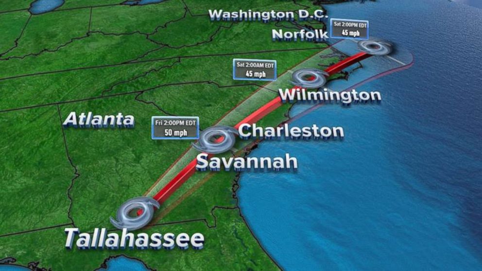
The weather could affect your plans this Labor Day weekend, so be sure to watch your weather channel. Tropical Storm Hermine will continue to affect Florida, Georgia and the Carolinas through Friday night and the coming days.
The storm made landfall as a hurricane in Florida early Friday, bringing strong winds and flooding to a wide swath of the state's Gulf coast, before being downgraded to a tropical storm.
The National Weather Service said much of northwest Florida and southern Georgia will be blanketed with 5 to 10 inches of rain in total through Friday, with maximum amounts of as much as 15 inches falling in isolated areas. A few tornadoes are also possible Friday morning across northern Florida and southern Georgia.
The eye of the storm is expected to continue moving across southeast Georgia on Friday and across the coastal Carolinas on Friday night. Forecasters anticipate tropical storm conditions to continue near Hermine's center Friday morning and spread northward within the warning area along the Atlantic coast throughout the day and night.
Because of a dangerous storm surge and the tide, rising waters will continue to rush inland from the shoreline and flood normally dry areas near the coast. As of 8 a.m. ET Friday morning, the National Hurricane Center said, "there is a danger of life-threatening inundation within the next 12 to 24 hours along the Gulf coast of Florida from Indian Pass to Longboat Key."
The tropical system is expected to weaken while its center remains over land and winds in the warning area along Florida's Gulf coast should gradually diminish Friday. The latest forecast had Hermine's maximum sustained winds decreased to about 50 mph with higher gusts, as it approached the state's upper-Gulf Coast.
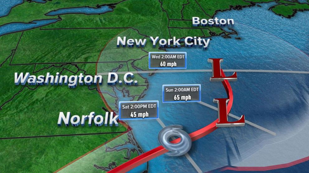
Forecasters expect Hermine's center to move offshore of the North Carolina coast o Saturday, likely allowing the storm to regain some strength. Tropical storm conditions are possible in the watch area on Saturday and Sunday. Heavy rain could reach the coastal Mid-Atlantic states from Virginia to New Jersey beginning early Saturday, according to the National Hurricane Center.
As of 11 a.m. ET Friday, the Tropical Storm Warning had been extended northward from Duck, North Carolina, to south of Fenwick Island, Delaware, including the Chesapeake Bay from Drum Point southward and the Tidal Potomac from Cobb Island eastward.
The Tropical Storm Watch had also been extended northward from Sandy Hook, New Jersey, to west of Watch Hill, Rhode Island, including Long Island and New York City, according to the National Hurricane Center.
ABC News' Max Golembo contributed to this report.
Related Topics

Popular Reads
ABC News Live