Hurricane Watch Issued for Florida Gulf Coast
Gov. Rick Scott said residents should have three days of food and water.
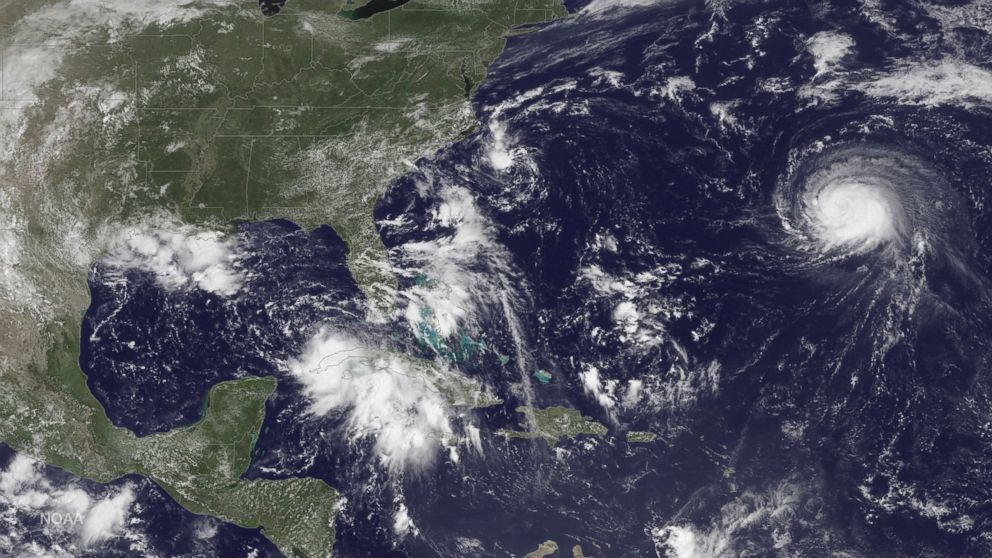
— -- The East Coast of the U.S. is bracing itself for severe weather as tropical depressions continue to churn in the Atlantic Ocean, bringing with them fears of hurricanes along the coast.
A hurricane watch has been issued for the Florida Gulf Coast from the Anclote River to Indian Pass, while a tropical storm watch has been issued for west of Indian Pass to the Walton/Bay County line.
In a press conference, Florida Gov. Rick Scott announced that the state will experience flooding, rain and rip currents, and recommended that residents have at least three days worth of food and water. He also said that the crews are working to curb non-travel-related cases of Zika by figuring out how to get rid of standing water.
So far, the depressions do not pose an urgent threat to any land mass, but Hurricane Gaston, a storm likely to finish its course in the Atlantic, has created rip currents apparently strong enough to drown a 26-year-old swimmer Monday evening in Long Beach, New York.
New Yorker Ed Fayans and his son, Maxwell, helped rescue another swimmer off Long Beach.
"If you don't know how to swim, and you're not on your game, those waves will pull you," Fayans, a surfer who witnessed the ordeal, told ABC's New York station WABC-TV.
A tropical depression that formed Sunday off the coast of North Carolina appears sluggish and disorganized this morning, and is likely struggling to survive.
A chance exists that it could become a weak tropical storm later today, hitting the outer banks of North Carolina. Because of the threat, the National Hurricane Center has issued a hurricane warning for the Outer Banks of the state.
Another tropical depression is further away, located north of Cuba and in the southern Gulf of Mexico, but is considered to be a more organized storm that could strike landfall north of Tampa on Thursday morning.
As for the Long Island drowning, it was the first such incident this summer, according to WABC-TV.
Another swimmer that lifeguards pulled out of the Atlantic survived, the station reported.
"Somebody came running up to tell us that there's two guys in the surf need help, and I only saw one,” Fayans told WABC-TV. “And then when I started running down, I saw a limp body in the surf, and I took that one and my son went out and got the guy who was way out that was losing it.”
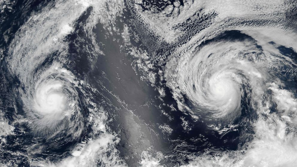
In the Pacific Ocean, satellite photos have captured two hurricanes heading side-by-side toward the Hawaiian islands, and they are expected to cause severe weather in the area late this week, the Central Pacific Hurricane Center told ABC News.
The first, Hurricane Madeline, is moving west with maximum sustained winds at 120 mph, making it a Category 3 storm. The forecast track takes the hurricane just south of the Big Island around Thursday morning. A hurricane watch has been issued for Maui and waters around the Big Island, and a tropical storm warning has been issued for the Big Island.
The main impact for Madeline will be heavy rain, dangerous waves, rip currents and damaging winds.
On Tuesday, the U.S. Coast Guard announced it was closing Hawaii County ports -- including Hilo Harbor and Kawaihae Harbor -- to all traffic at 8 p.m. local time. "Once the storm has passed and the threat of severe weather has subsided, the Coast Guard, Army Corp of Engineers and State of Hawaii will jointly conduct surveys of channel blockage and prioritize steps to resume essential, then normal, vessel traffic," read the statement.
Right behind Madeline is fellow Category 3 storm, Hurricane Lester, with winds up to 120 mph. It is currently heading west and could move just north of Hawaii on Saturday morning.
If both hurricanes make landfall, they will be the first back-to-back hurricanes to ever hit the Hawaiian islands, the Central Pacific Hurricane Center told ABC News.
ABC News' Melissa Griffin contributed to this report.
Related Topics

Popular Reads

ABC News Live