New Year's Eve Forecast Brings the Big Chill to Nation
It's a frigid start to 2015 for most of the nation, even California and Vegas.
— -- New Year's Eve revelers will need heavy coats and boots in much of the country this evening -- even in places that aren't used to wintry weather.
It will be a snowy start to the New Year for much of the Southwest with winter storm warnings and advisories stretching from Southern California to Western Texas.
Las Vegas could even get a little snow, and the last time that happened was back in 2008. But even a dusting on the strip could cause dangerous travel and delays as partiers pile in to celebrate the new year. Temperatures will drop below freezing on New Year's Eve. On Tuesday, the city dropped below freezing for the first time in 381 days.
Los Angeles and San Diego counties are under a winter storm warning through today, with 1-3 inches for the high deserts, and up to a foot in the mountains. Much of California will be feeling the bitter cold by Thursday morning.
A freeze watch is in effect from just north of Los Angeles to South of San Francisco, where temperatures are expected to drop into the 20s and 30s. Pasadena will see near-record low temperatures on New Year’s Day just in time for the Rose Parade.
Temperatures will potentially fall to a record 32 degrees Thursday morning, while the parade starts at 8 a.m. The previous record of 32 degrees was set back in 1952. Daytime highs are only expected to be in the mid-50s, along with plenty of sunshine.
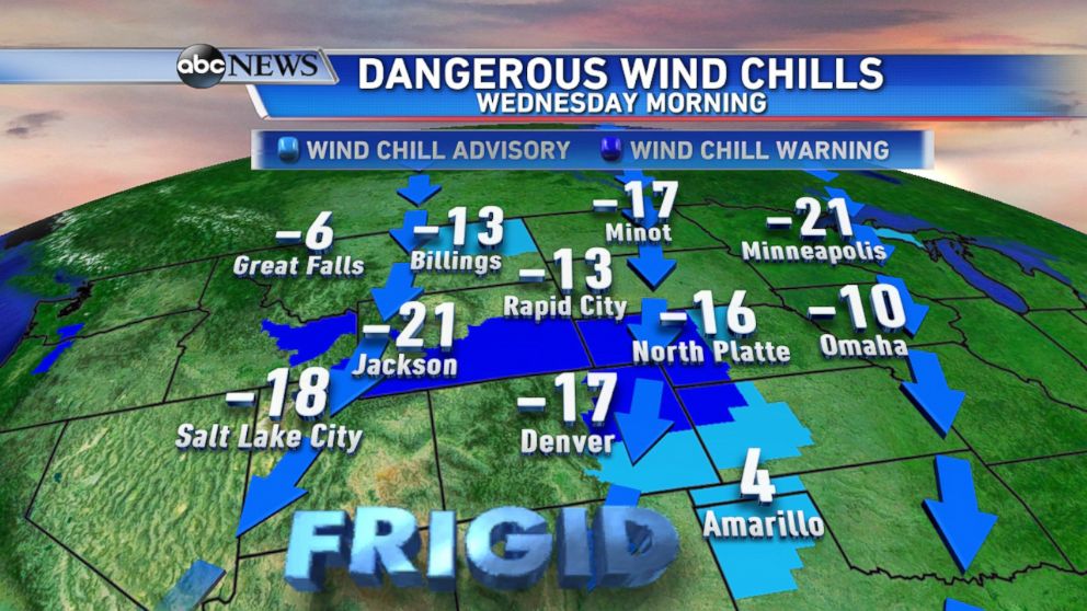
A bone-chilling Arctic air mass has been filtering into the heartland this week and will continue to bring temperatures up to 30 degrees below normal as we enter 2015. Wind chill advisories and warnings stretch from Michigan to Texas and up to Montana. Very cold temperatures combined with gusty winds will make it feel 10 to over 20 degrees below zero during the morning hours.
Besides snow and icy conditions in the Southwest, much of the country will be dry but quite cold on New Year’s Eve. Temperatures from Nevada to Denver to Minneapolis will be in the single digits or lower. Wind chills could be 10-20 degrees below zero.
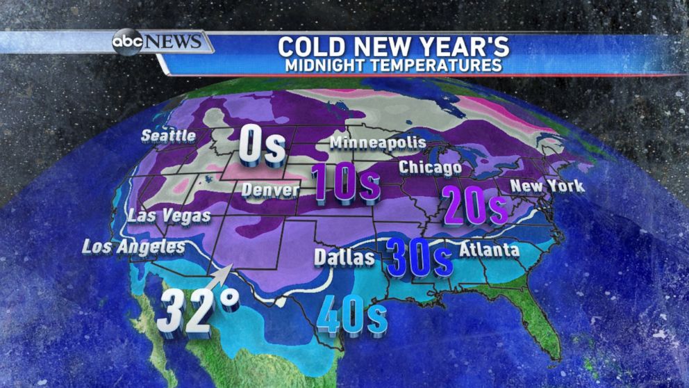
The white line represents the freezing line, and look how far south it drops. Every state in the country will likely see temperatures near freezing or below except for Florida. The Times Square ball drop forecast will feature temperatures in the 20s, with wind chill values in the teens, under mostly clear skies.
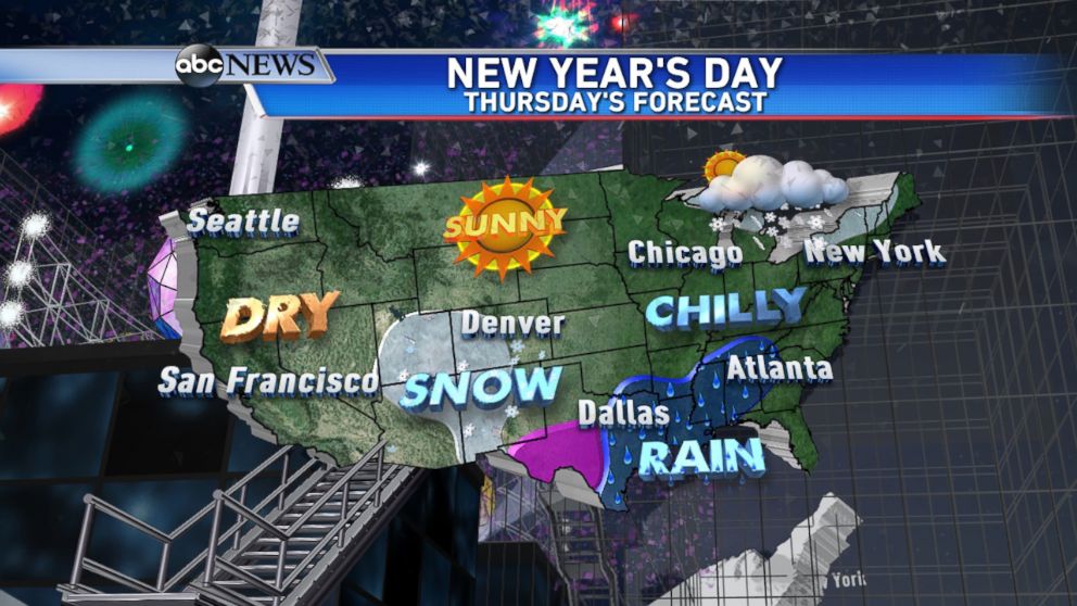
Here is the national forecast for New Year’s Day: Again much of the country is dry and cold. That storm system in the Southwest will continue to push east, bringing snow to the Rockies, icy conditions to west Texas, and heavy rain along the Gulf Coast.
In addition, the lake effect snow machine will be on full blast through the New Year. Lake effect snow watches and warnings are up for parts of New York state, including Buffalo and Watertown, where up to 2 feet of snow could fall. Although it will be pretty chilly in the East the rest of the week, temperatures are actually only a few degrees below normal; it just feels colder because December was so mild.
The blast of cold for much of the country as we start the New Year is just a reminder winter has only just begun.

Popular Reads
ABC News Live