Coldest Temperatures In Years Blast U.S., Prompting Polar Vortex Chatter
Persistent blasts of Arctic air have been keeping it bitter cold.
— -- Once again the relentless stretch of bitter cold battering Northeastern cities including Boston with record snow has many people wondering if the polar vortex is here.
On Monday morning, Boston experienced its coldest temperature since 2004, and New York City woke up to the coldest February morning in 28 years. Record cold temperatures were set from Ohio to Virginia, and all the way up to New England.
You may remember when the term polar vortex became popular last winter. The relentless and record-breaking cold experienced last year had many Americans looking for an explanation, and February of this year has been just as bad if not worse in many Northeastern cities.
Though the term makes good headlines, the truth is the polar vortex is still circulating near and around the North Pole where it's almost always positioned. What much of the country is dealing with is a persistent chain of Arctic air masses plunging south into the continental U.S., a common situation for winter.
A majority of the time, the frigid cold experienced during the winter months is not related to the polar vortex. In fact, as the winter season progresses, the cold air masses to the north across Canada, are growing colder or "maturing". As this happens, it also helps promote the likelihood of more frequent, and intense shots of Arctic air to move over the United States later in the winter season.
However, the arctic blast that is on the way for the second half of the week will likely be a case where the Arctic air moving in is directly influenced from part of the polar vortex itself.
Here's a recap:
The polar vortex has been known about and studied by the meteorological community for decades. It is an almost always present upper-level circulation that hangs out most of the of time around both the North and South Poles. The circulation is at it's strongest during the winter months. It is not at the surface, nor is it an actual storm system. It is also not related to every push of cold air.
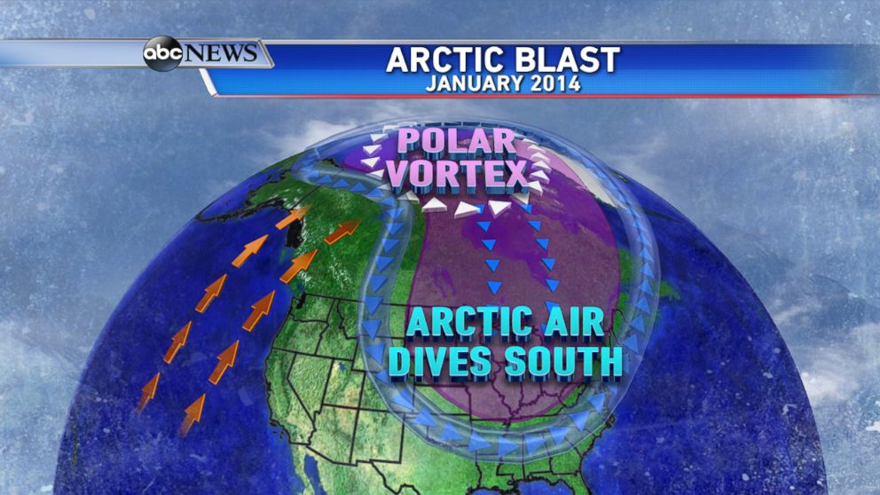
ABC News Chief Meteorologist Ginger Zee says the polar jet stream is like a fence keeping the air influenced by the polar vortex in place. During the first week of January 2014, the polar jet stream was kinked enough to build a large ridge in the west and allow a lobe of the polar vortex to slip southward into Canada, greatly influencing the air that set records in the northern plains and Great Lakes.
Last year the northern Plains and Midwest were hit the hardest, but this year the pattern that set up has the trajectory of the coldest air focusing a bit more to the east.
Over the past several weeks, the jet stream has been locked in a similar pattern allowing for numerous shots of Arctic air to move right down from Canada.
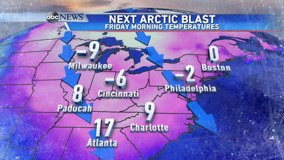
Later this week, yet another blast of Arctic air will arrive, keeping temperatures well below normal through the end of the week across most of the eastern part of the country. A piece, or lobe of the polar vortex will displace itself father south in Canada and influence the bitter cold air moving in.
Looking ahead, there are no indications that this pattern will be changing, leaving the gate open for more blasts of Arctic air to plunge down from Canada. The next time major cities such as Philadelphia, New York, and Boston can expect to reach above the freezing mark will be towards the end of the upcoming weekend. Forecast highs for this upcoming Sunday are currently in the mid to upper 30s.
However, this return to an average mid-late February feel will be short lived, as several additional shots of Arctic air look to be in store right through the end of the month and even into the first few days of March.

Popular Reads
ABC News Live