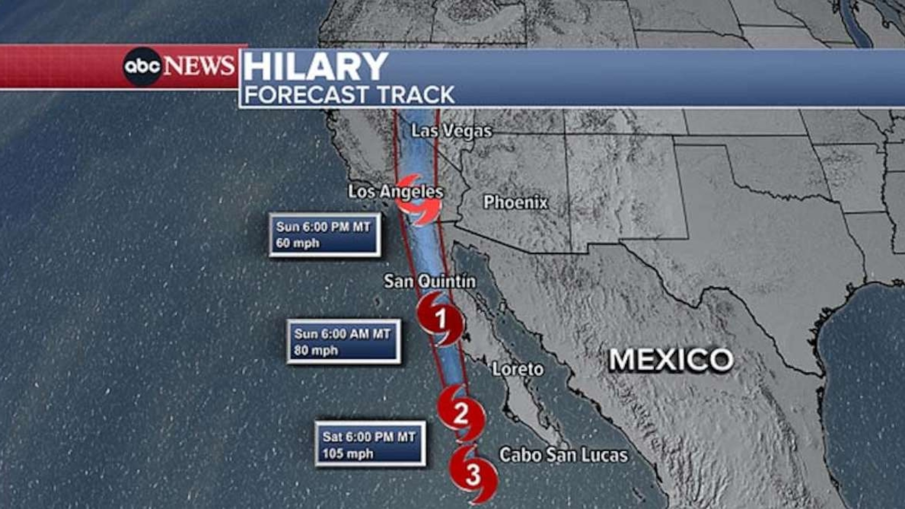
Hilary expected to bring catastrophic, life-threatening flooding to US Southwest
A tropical storm warning has been issued for Southern California.
Tropical storm warnings are in effect for more than 42 million Americans in Southern California, with Hilary expected to be the first tropical storm to hit the region since Nora in 1997.
Hurricane Hilary has entered cooler water and is starting to weaken. The storm was downgraded to a category 2 hurricane with maximum sustained winds of 110 mph as of Saturday afternoon.
The center of Hilary is located roughly 285 miles south-southeast of Punta Eugenia, Mexico, and 640 miles south-southeast of San Diego, California.


The storm was moving slowly at 17 mph to the north-northwest.
The cyclone will continue to weaken as it continues into increasingly colder water over the coming days and especially as it reaches land.
A sustained wind of 44 mph and a gust of 63 mph were recently reported at the Cabo San Lucas Marina. Worsening conditions are expected for parts of the Baja California Peninsula into Saturday evening.
Rain will start to reach southern California and Arizona later Saturday and continue into Monday.


Landfall is expected in Mexico on Sunday, possibly in the northern part of the Baja California Peninsula. The storm is then expected to be at tropical storm strength as it enters southern California.
In the unlikely event that Hilary makes landfall in California -- instead of in Mexico, the most likely scenario -- it will be the first landfalling tropical storm in California since 1939.
A tropical storm warning remains in effect for portions of southern California, including San Diego, Palm Springs, Riverside and Los Angeles. This is the first time the National Hurricane Center has issued a tropical storm warning in this region.


Tropical-storm-force sustained winds up to 73 mph are possible near San Diego. Los Angeles could see sustained winds up to 57 mph.
Flood watches are in effect from Southern California and Arizona to Oregon and Idaho and tropical storm conditions are expected to begin in southern California on Sunday.
There is a major to extreme flood risk in Southern California. Heavy rainfall in association with Hilary is expected across the Southwestern United States, peaking on Sunday, and possibly lasting through Monday.
The National Oceanic and Atmospheric Administration's Weather Prediction Center issued a rare "high risk" forecast for excessive rainfall for Sunday across a large swath of Southern California, from Palm Springs up toward Death Valley. The deadliest hazard associated with tropical cyclones over the past decade is flooding from heavy rain.
Rainfall amounts of 3 to 6 inches, with isolated amounts of 10 inches, are expected across portions of Southern California and southern Nevada. Dangerous to locally catastrophic flooding is likely.

Elsewhere across portions of the Western United States, rainfall totals of 1 to 3 inches are expected, resulting in localized flash flooding.
A tornado or two may occur Sunday over parts of the lower Colorado River Valley, Mojave Desert and Imperial Valley regions.
Climate change projections show California may see an increase in extreme rainfall from tropical cyclones by the end of this century. While climate change can decrease the overall number of tropical cyclones, it can increase the number of major (category 3-5) tropical cyclones.


