Hot weather in store for eastern half of country on Father's Day
Temperatures will feel like 100 degrees in the central U.S.
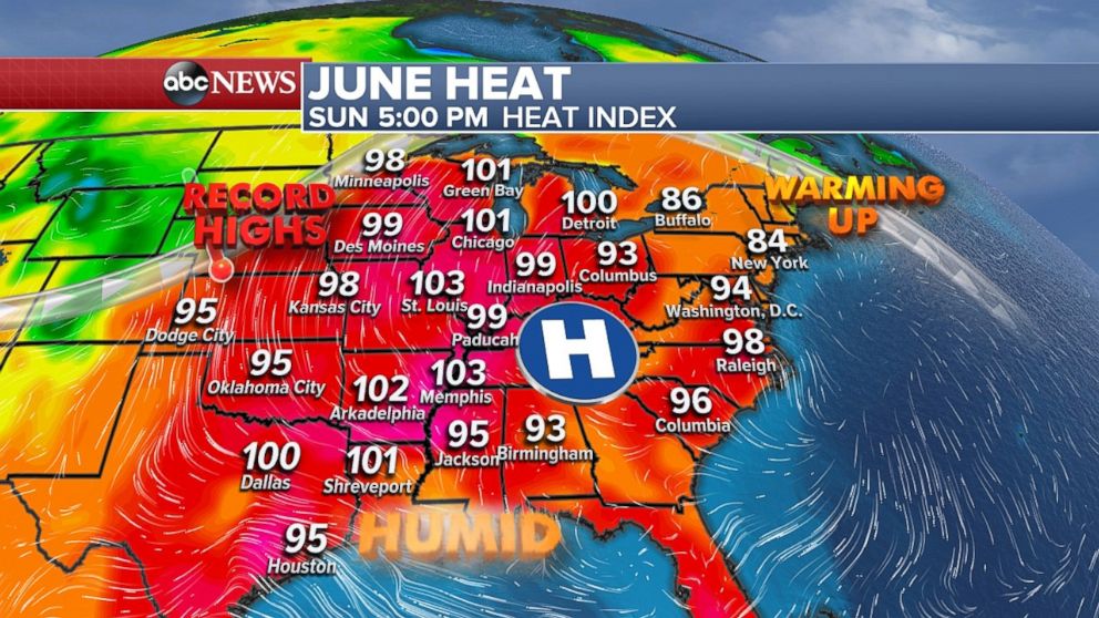
Much of the central U.S. will be dealing with widespread heat on Sunday as heat index values are close to, or exceeding, 100 degrees in parts of the Midwest, including Chicago.
Heat index values close to, or in excess of, 100 degrees are possible from Texas to Michigan, including Dallas; Little Rock, Arkansas; Memphis, Tennessee; St. Louis, Chicago and Detroit.
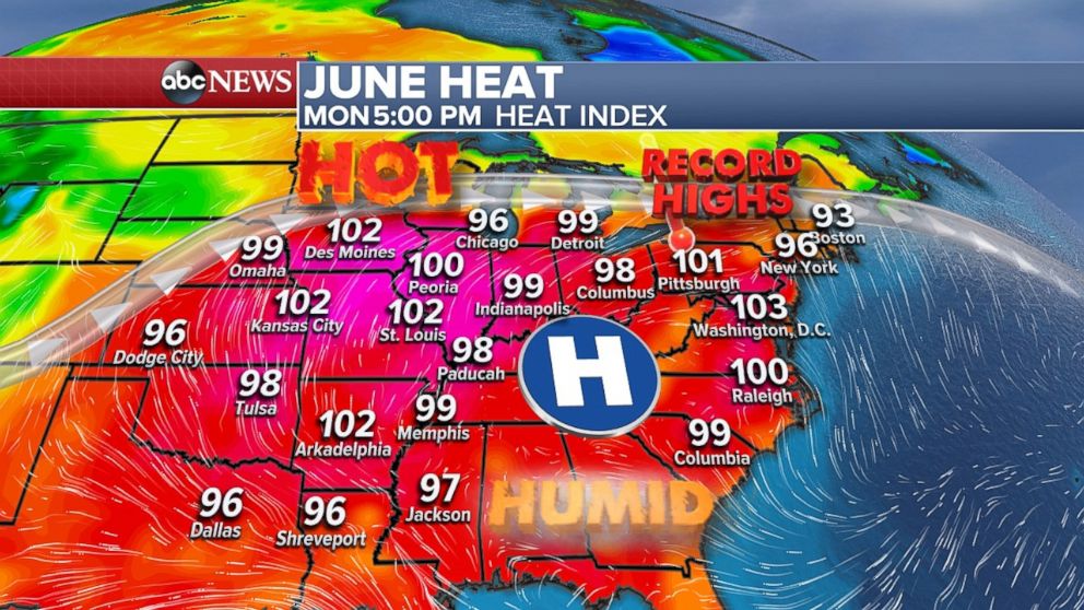
On Monday, the heat expands to the east with heat index values nearing or exceeding 100 degrees again for much of the Midwest, including Kansas City, Indianapolis and Detroit.
Parts of the Northeast will also get quite warm, with heat index values in the upper 90s in New York and Philadelphia. In the mid-Atlantic, heat index values near or above 100 are possible from South Carolina to Maryland.
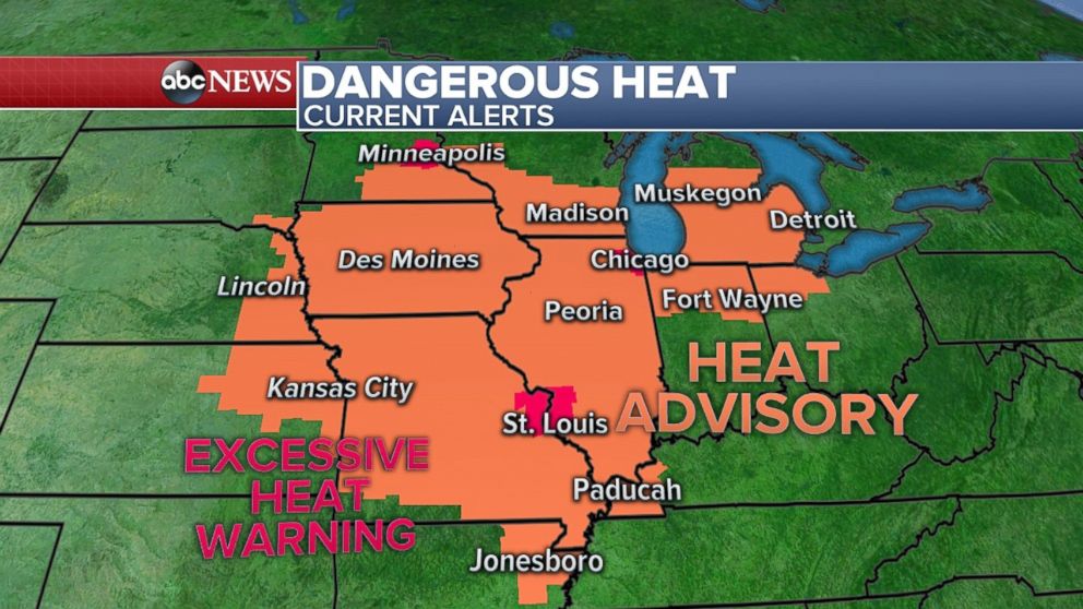
Heat advisories are in effect from northern Arkansas to southern Michigan and excessive heat warnings are in effect in St. Louis, Chicago and Minneapolis. These heat index values can become dangerous.
This stretch of heat shows little relief at night, especially in many of the urban areas, such as Chicago and New York.
Severe threat in Northern Plains
Slow-moving, strong thunderstorms dumped very heavy rainfall overnight in northern Minnesota and Wisconsin. There have been reports of over 3 inches per hour just south of Duluth, Minnesota. Radar estimates from the region show possible rainfall totals exceeding 6 inches since late Saturday night.
The National Weather Service in Duluth relayed reports of numerous roads washed out in the region due to flash flooding. Flash flood watches have been posted for parts of the region through Sunday due to the threat of strong thunderstorms.
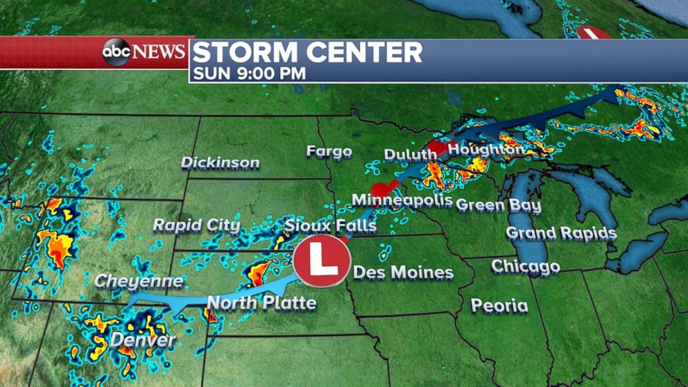
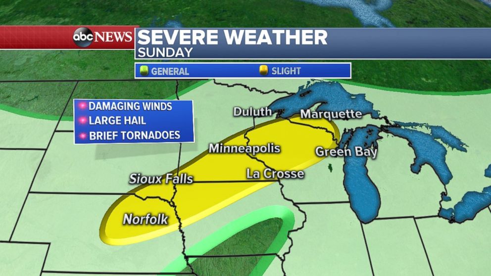
Numerous strong to severe thunderstorms will develop again Sunday from Colorado to northern Michigan. These storms will once again have the potential to dump very heavy rain and bring strong gusty winds, large hail and brief tornadoes.
There is a slight risk for severe weather Sunday from eastern Nebraska to northern Michigan, an area that includes Minneapolis.
Locally, 2 to 3 inches of rainfall is expected in this region by Monday evening, with pockets of flash flooding possible.
Tropical wave approaches Gulf Coast
A cluster of thunderstorms in the Gulf of Mexico has a 20 percent chance of gaining tropical cyclone characteristics over the next few days. Even though development is not likely, this tropical wave will gradually move toward Texas and northern Mexico over the next few days.
The system will bring numerous rounds of heavy downpours and thunderstorms to the region during the upcoming work week. Over the course of the next three to four days, there is increasing potential for rainfall totals to exceed 4 to 6 inches in parts of southern Texas, including Brownsville, Corpus Christi and Port Lavaca.

There is some computer guidance suggesting rainfall totals could be higher than what is currently forecast. Even though much of this region can deal with a good amount of rain before major flooding concerns, some flash flooding could develop in this region in the coming days.
Related Topics

Popular Reads
ABC News Live