Tropical Storm Sally forms, takes aim at Gulf Coast
The storm is the 18th to be named, a new record for earliest at this date.
Tropical Depression 19 officially strengthened into Tropical Storm Sally Saturday afternoon.
Sustained winds were at 40 mph, and it is moving west at 7 mph with the center about 30 miles south-southwest of Naples, Florida.
This sets a new record for the earliest 18th-named storm of the season in the Atlantic Basin. The previous record was Stan on Oct. 2, 2005.
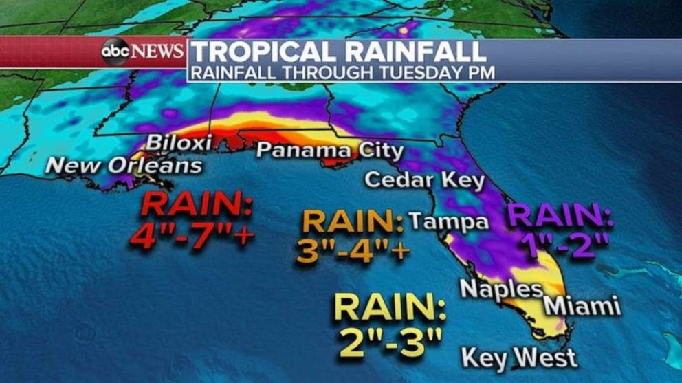
The current forecast track has the storm slowing down as it approaches the Gulf Coast beginning on Monday. This means the potential for extreme rainfall totals and dangerous storm surge. Early forecasts call for storm surge of 6 to 9 feet possible from the mouth of the Mississippi River to portions of the Mississippi coast. The forecast also predicts that parts of the north-central Gulf Coast could see 5 to 10 inches of rain, with over a foot possible. Locally, heavy rain is expected to last through much of the weekend from Naples to Fort Myers to Tampa.
Hurricane watches have been issued from Grand Isle, Louisiana, to the Alabama/Florida state line, and tropical storm watches are in effect for parts of the Florida panhandle. Storm surge watches are also in effect from the mouth of the Mississippi River to the Alabama/Florida state line.
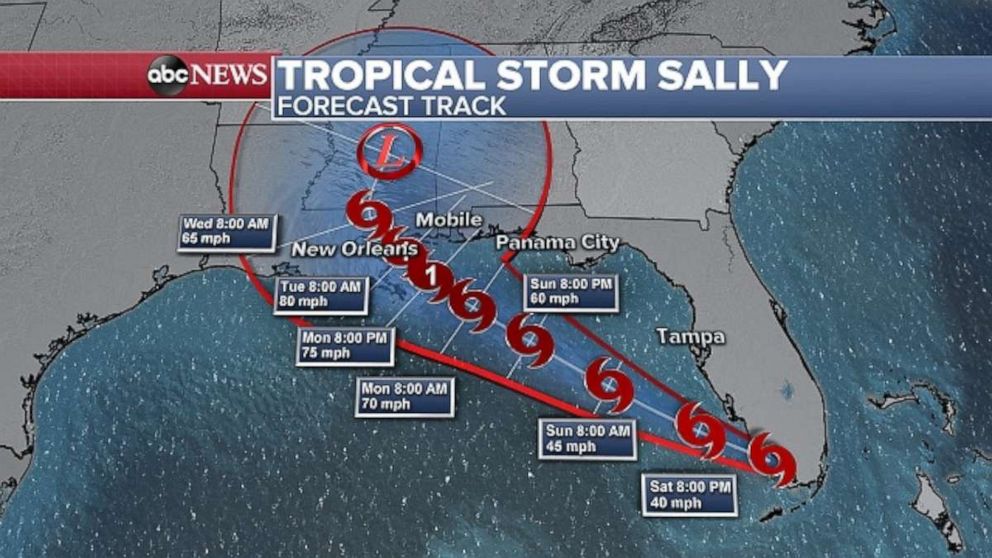
The latest forecast now calls for this system to be a Category 1 hurricane by Monday afternoon and potentially make landfall late Monday night or Tuesday.
Louisiana Gov. John Bel Edwards declared a state of emergency Saturday afternoon in anticipation of the storm.
"While we ultimately don't know where Sally will make landfall, much of Southeast Louisiana is in the storm's cone and the risk of tropical storm force or hurricane strength winds continues to increase. Please stay weather aware for the next several days and heed the directions of your local officials. This storm has the potential to be very serious," Edwards said in a statement.
As with all hurricanes and tropical systems, the worst impacts are always on the right side of the storm. There is a window of opportunity over the coming days for the storm to strengthen, and a strengthening storm as it approaches land can be a tough forecast to nail down.
Ultimately, though, the immediate concern is a slow-moving storm that could bring a serious rainfall threat to the Gulf Coast in the coming week.
More systems to watch
Elsewhere in the Atlantic basin, there are several systems worth watching.
One is a tropical wave drifting westward in the Gulf of Mexico. There is Tropical Storm Paulette, which will near Bermuda as a hurricane, possibly Category 2, by Monday. There is also Tropical Storm Rene, which will likely weaken to a tropical remnant low sometime this week.
Tropical Depression 20 has also just formed over the south-central Atlantic Ocean. It is forecast to strengthen into Tropical Storm Teddy on Sunday and become a hurricane later next week as it turns northward. At this time it looks to remain over the middle of the Atlantic not have any threat to land.
At this point, the primary concern to the United States remains Tropical Storm Sally.
Wildfires remain a concern in West
Meanwhile, air quality is expected to remain unhealthy across the western U.S. through much of the weekend as numerous large wildfires continue to burn across the region.
Satellite imagery actually shows a unique situation where a strong storm over the Pacific Ocean is essentially pulling smoke from the fires westward and trapping hazardous air in the major population centers. NASA is reporting that the smoke has traveled nearly 1,300 miles across the western U.S. and eastern Pacific Ocean.
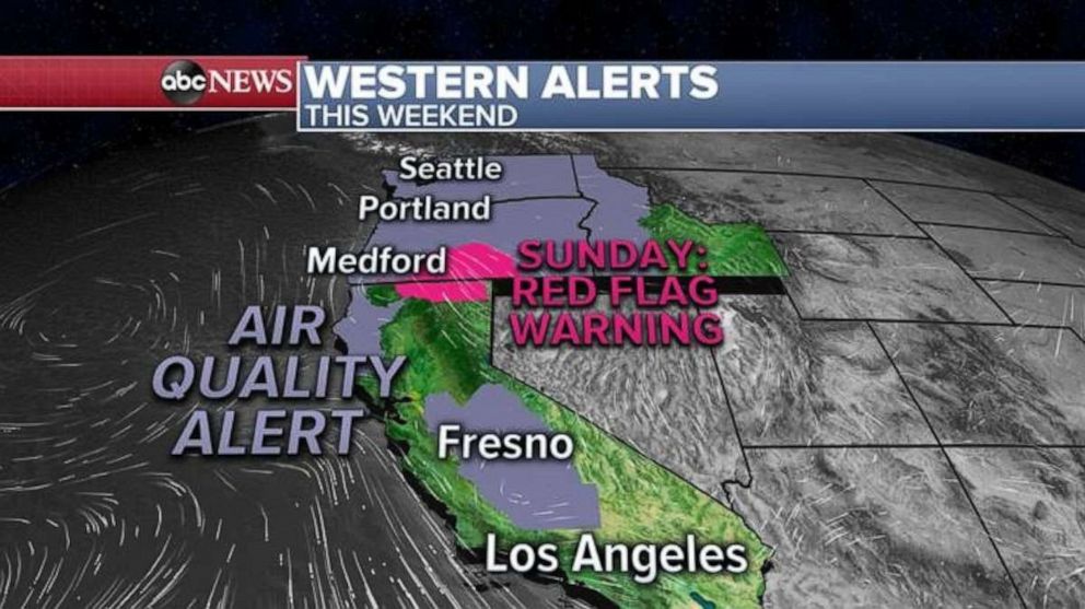
As that storm approaches, it will likely kick up some wind activity across parts of the west on Sunday and a red flag warning has been issued there. The good news is once that period of critical fire danger is over, wetter and cooler conditions next week should reduce the risk for fire spread and help clear out the dangerous air.
Related Topics

Popular Reads
ABC News Live