East Coast Nor'easter: What Forecasters Got Right and Wrong
More than two feet of snow buried the New York City area.
— -- Over the past week, meteorologists were watching for the possibility of a major nor'easter to slam the East Coast. Two uncertainties remained leading right up to the start of the event: how far north the heavy snow would make it up the East Coast and if New York City would be hit with the brunt of the storm.
As the snow started, it quickly became more evident that the heavier snow bands were forming about 30 to 40 miles farther north than initially expected. Heavy bands of snow, with snowfall rates ranging from 2 to 4 inches per hour, made it to New York City during the day on Saturday. The overall slow movement of the storm allowed for the bands to remain rather stationary over a large chunk of the New York Metropolitan area, resulting in rapidly accumulating and excessive snow.
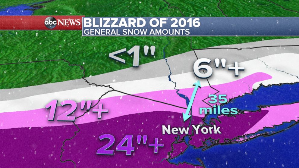
Our observations showed that there was indeed a very sharp drop off of totals as you head from New York City toward the north. While New York City and its suburbs to the east and west received approximately 2 feet of snow, suburbs north of the city saw about four times less. For instance, Tenafly, New Jersey, received 24 inches of snow while Brewster, New York, got just 6 inches.
Meteorologists build their forecasts using a combination of forecast models, climatology and experience. The first indications that a potential major nor'easter was going to develop came about a full week ahead of this weekend’s blizzard.
There are several forecast models meteorologists rely on to make a forecast, including short-range and medium-range models. With this particular event, our medium-range models hinted of a major snow event days in advance, with the Mid-Atlantic and Northeast receiving about 1 to 2 feet of snow.
These models, however, seemed to lack consistency with the placement of the boundary between very heavy snow and lighter snow. This uncertainty happened to fall over America's most populated city, New York.
As the event came closer, higher resolution forecast models began to indicate that this line of heavy snow could indeed come very close to New York City, and perhaps even make it to the city's suburbs.
There was always the possibility that many cities, including New York, would receive a large amount of snow. The concern over forecasting feet of snow in New York City without complete confidence led to a conservative approach among meteorologists across the area.
