'Pure hell': Category 5 Hurricane Dorian brings historic destruction to Bahamas
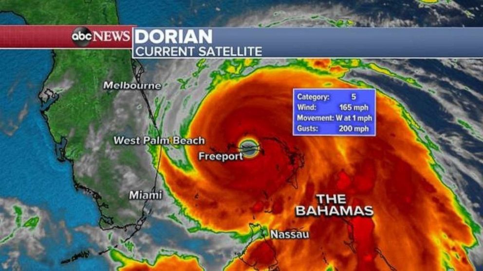
Hurricane Dorian is now a Category 5 hurricane with sustained winds of 165 mph.
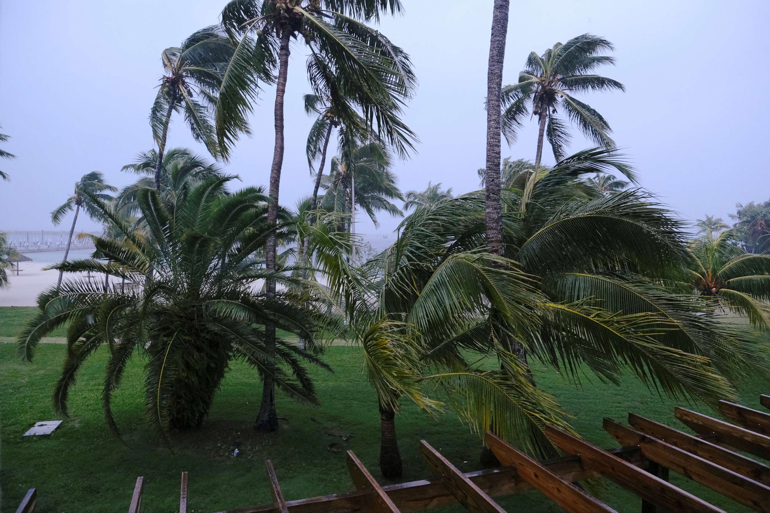
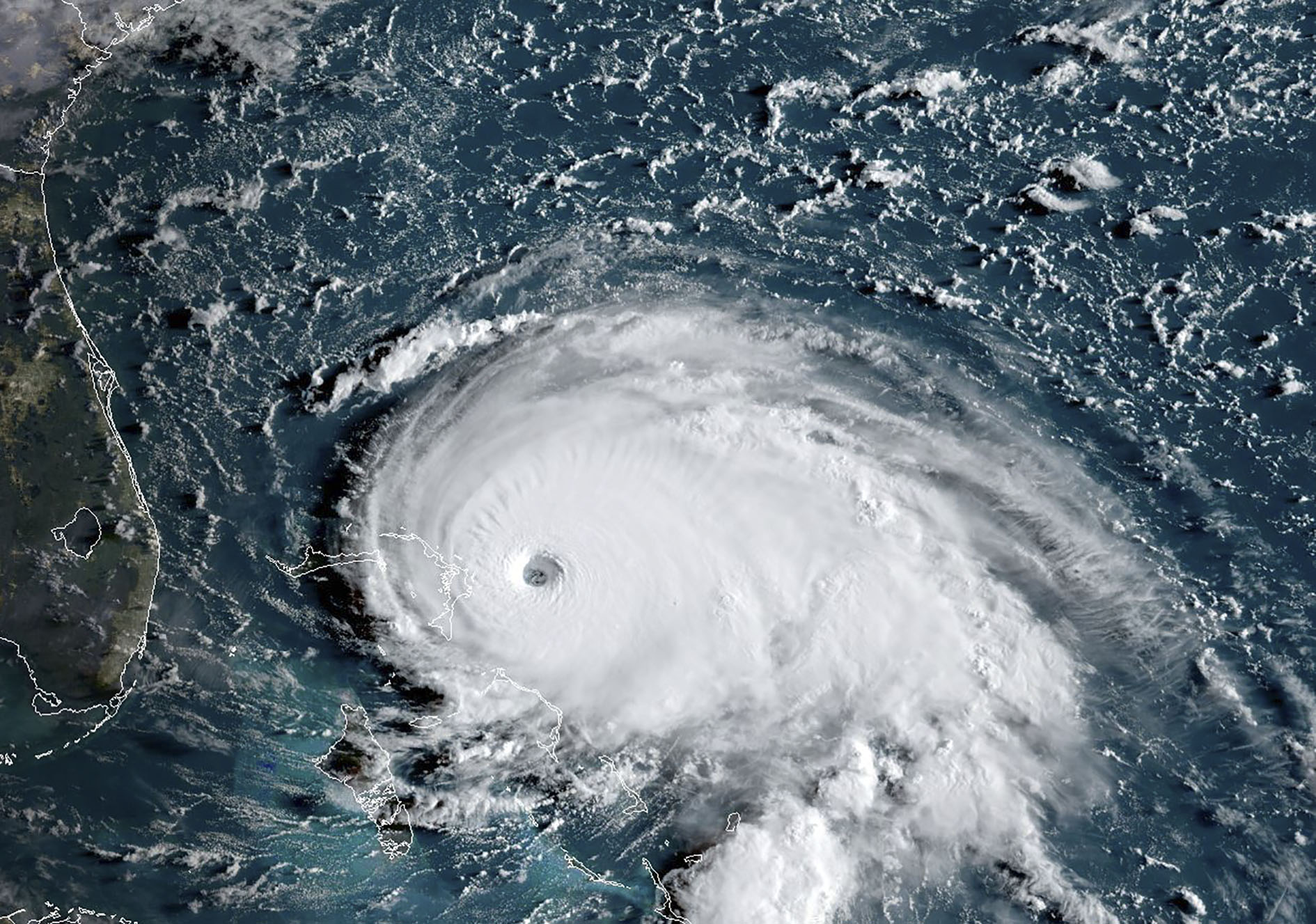
Hurricane Dorian is a massive Category 5 hurricane Monday morning with sustained winds of 165 mph as it continues to batter the Bahamas in the Atlantic Ocean.
Dorian, which came ashore on Elbow Cay of the Abaco Islands, is tied for the strongest Atlantic hurricane landfall on record, along with a hurricane on Labor Day in 1935 that struck the Florida Keys and moved up along the Gulf Coast of Florida.
Winds are currently blowing at a sustained 165 MPH -- the same strength that Hurricane Andrew had when it hit parts of the Miami metro area in 1992.
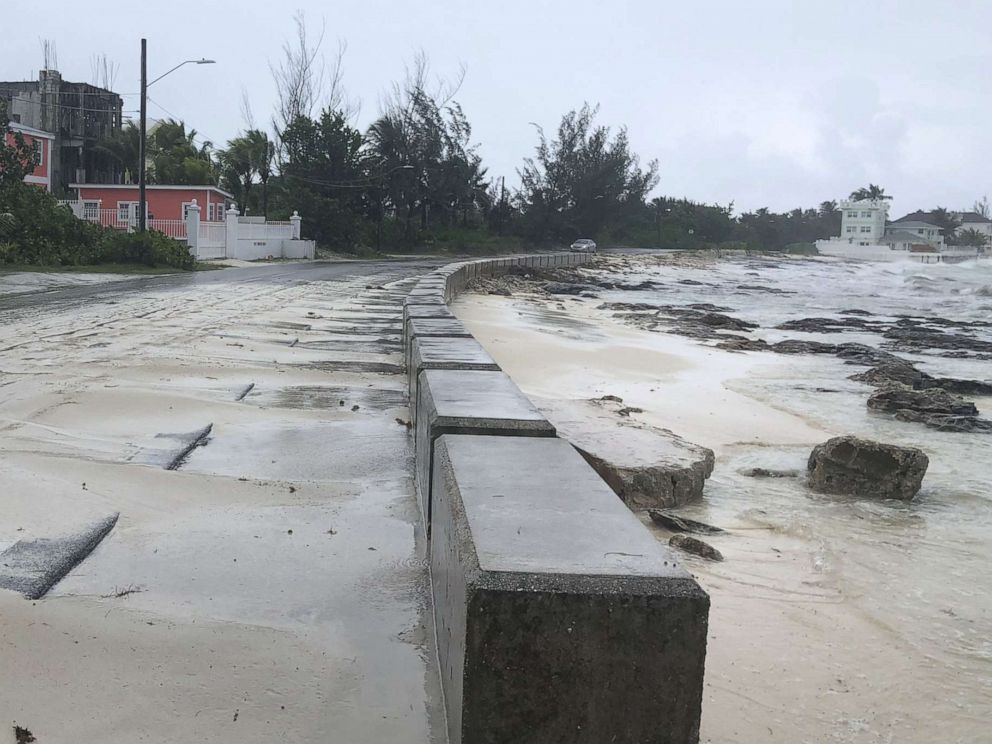
The eye of the storm made a second landfall at 2 p.m. on the island near Marsh Harbour, and a third landfall an hour before midnight on the eastern end of Grand Bahama Island.
Francis Charles, who rode out the storm in Hope Town, Elbow Cay, called the island "a wreck" late Sunday.
"I have never seen anything like this in my life," Jenise Fernandez, reporter with Miami ABC affiliate WPLG, told the station during their broadcast.
ABC News correspondent Marcus Moore, who is on the ground in Marsh Harbour, described the scene as "pure hell."
"I have seen utter devastation here in Marsh Harbour. We are surrounded by water with no way out," Moore said. "Absolute devastation, there really are no words it is pure hell here on Marsh Harbour on Avoca Island in the northern part of the Bahamas."

The National Hurricane Center is calling the storm a life-threatening situation with extreme destruction and the potential for wind gusts over 200 mph.
"Today I gave a live national briefing on the extremely dangerous #HurricaneDorian from NEMA Headquarters," Bahamas Prime Minister Hubert Minnis said in a tweet Sunday night. "This is probably the saddest and worst day for me to address the Bahamian people. We are facing a hurricane that we have never seen in The Bahamas. Please pray for us."
The town of Marsh Harbour on Great Abaco island has catastrophic damage, according to an ABC News team on the ground, with boats on rooftops and uprooted trees.
It is the strongest hurricane in modern record for the northwestern Bahamas.
But with the slow motion of Dorian, the prolonged duration of hurricane and tropical storm force winds with gusts over 200 mph, storm surges of up to 20 feet and heavy rainfall will continue to devastate the northern Bahamas.
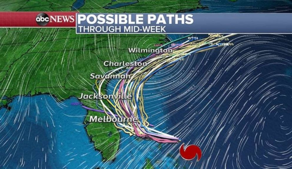
According to the current path of Hurricane Dorian, it looks like the closest passage to Florida will be near Cape Canaveral by Tuesday night into Wednesday morning with forecast sustained winds of 125 mph which would make it a Category 3 hurricane. Regardless of landfall, wind gusts of up to 80 mph and storm surge will be the biggest threats for eastern coast of Florida next few days.
As Dorian makes its northward turn Monday into Tuesday: Georgia, South Carolina and North Carolina should remain on high alert. Although the official National Hurricane Center track keeps the center of Dorian right off the coast as of now, the impacts will still be greatly felt.
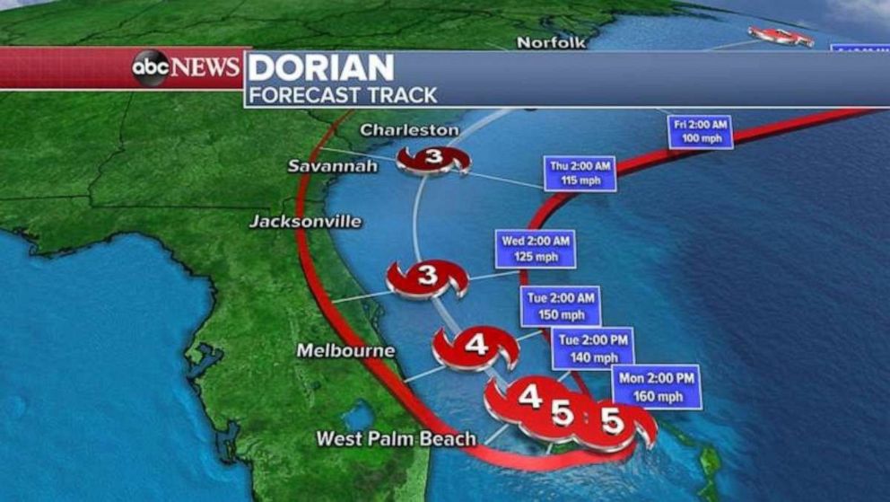
Beyond Wednesday, Hurricane Dorian will turn to the northeast and come really close to the Carolinas, especially near Wilmington and up to Cape Hatteras. At that time, Dorian is expected to be a Category 2 hurricane near with sustained winds around 100 MPH.
On Sunday, Florida Gov. Ron DeSantis announced that tolls on the state's turnpike mainline will be suspended for aid evacuations.
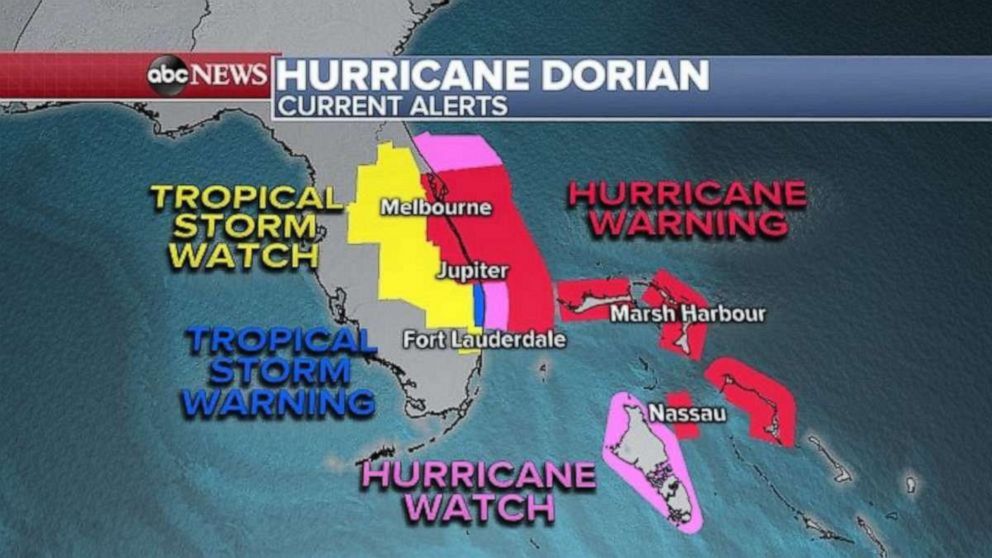
A hurricane warning is in effect for Florida's east coast from Jupiter all the way to the Florida-Georgia border.
Palm Beach County International Airport, Orlando Melbourne International Airport and Fort Lauderdale-Hollywood International Airport will cease operations on Monday at noon. Orlando International Airport will not be closing.
The biggest threat for Florida over the next few days will be storm surge. From West Palm to Jacksonville storm surge could reach 7 feet during an astronomical high tide due to the new moon. Significant flooding is also expected in coastal Florida over the next few days.
Dorian will still likely be a Category 2 storm with winds over 100 mph just off the coast when the storm makes its closet approach to South Carolina and North Carolina Thursday into Friday.
There is still high uncertainty in the track three to five days out and Dorian still has the potential to make landfall in the southeast states.
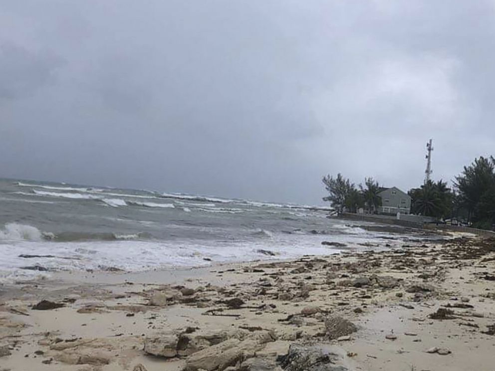
The Bahamas should expect storm surges of up to 15 to 20 feet, rainfall of up to 30 inches and prolonged hurricane-force winds, large and destructive waves and wind gusts of over 100 mph.
It is difficult to predict what to expect along the coast of the southeast through the mid-Atlantic of the United States, but isolated rain totals of over 10 inches could be possible with tropical storm force winds and life-threatening surf and rip currents.
North Carolina Gov. Roy Cooper declared a state of emergency for all counties Sunday afternoon.
"North Carolina has endured flooding from two strong hurricanes in less than three years,” Cooper said in a press release announcing the declaration. "Now is the time to prepare for Dorian. To the people of North Carolina, particularly those still recovering in the eastern part of our state, we are working hard to prepare and we are with you."
South Carolina Gov. Henry McMaster ordered mandatory evacuations for coastal counties beginning on Tuesday. Georgia Gov. Brian Kemp later did the same in his state.
Heavy rains, capable of producing life-threatening flash floods are possible over coastal sections of the Southeast and lower mid-Atlantic regions of the United States through late this week.
Mandatory evacuations in Florida
Palm Beach County: Areas east of the intracoastal waterway including coastal sections of Jupiter, Palm Beach and Boca Raton. Beginning on Sunday at 1 p.m.
Volusia County: Residents on the beach side, in low-lying areas and mobile homes throughout the county. Beginning on Monday at 10 a.m.
Martin County: Barrier islands (including Hutchinson Island, Jupiter Island), Sewall's Point and low-lying coast areas and manufactured homes. Beginning on Sunday at 1 p.m.
St. Lucie County: Barrier islands and low-lying coastal areas and manufactured homes. Beginning on Sunday at 2 p.m.
Indian River County: All areas east of U.S. Highway 1 including barrier island. Beginning on Monday at 8 a.m.
Brevard County: Barrier islands (including areas from Kennedy Space Center South to the South Beaches, Merritt Island) and low-lying coastal areas and manufactured homes. Beginning on Monday at 8 a.m.
St. Johns County: Zones that include the entire City of St. Augustine, the City of St. Augustine Beach, waterfront or flood-prone areas and manufactured homes. Beginning on Monday at 8 a.m.
Duval County: Zones that include Jacksonville beaches. Beginning on Monday at 8 a.m.
Nassau County: Issued for zones A, C and F.
Mandatory evacuations in South Carolina
Southern Coast: Colleton County evacuation zones A and B; Beaufort County evacuation zone A; Jasper County evacuation zone A
Central Coast: Charleston County evacuation zones A, B and C; Dorchester County evacuation zone D; Berkeley County evacuation zones B and G
Northern Coast: Horry County evacuation zone A; Georgetown County evacuation zone A
Mandatory evacuations in Georgia
Individuals east of Interstate 95 in Bryan, Camden, Chatham, Glynn, Liberty and McIntosh counties at noon on Tuesday
Residents should have their hurricane plan in place, know if they are in a hurricane evacuation zone, and listen to advice given by local emergency officials.
ABC News' Brittany Borer and Marcus Moore contributed to this report.
Related Topics
Popular Reads
ABC News Live