Major storm moving through central US as separate storm follows behind
Over 6 inches of rain has been reported in southern Missouri.
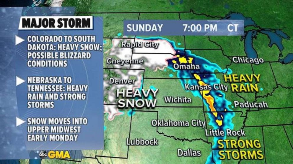
A major storm continues to impact the Central U.S. on Sunday morning with heavy snow, torrential rain and severe weather.
Since the start of the storm on Friday, there have been at least 14 reported tornadoes in the Texas Panhandle with 11 of those reported tornadoes occurring on Saturday.
Additionally, wind gusts on Saturday reached as high as 87 mph in the Texas Panhandle and the region experienced baseball-sized hail.
Over 6 inches of rain has been reported in southern Missouri and over 4 inches of rain has been reported in Kansas and Nebraska, with all three states seeing flooding due to the storm.
On the colder side of the storm, Denver has already received 7 inches of snow and Cheyenne has already received 8.1 inches with more snow on the way.
Snowfall rates this morning are 1 to 2 inches per hour in Colorado and Wyoming, with locally up to 4 inches per hour in the foothills and mountains.
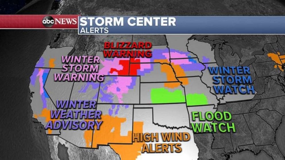
This morning there are still blizzard warnings for parts of South Dakota, Nebraska, and Wyoming.
There are also numerous other winter weather alerts issued for parts of Colorado and the upper Midwest as the storm slowly moves eastward.
The heavy snow will continue through the day with dangerous travel conditions in the high plains of Colorado and Wyoming as well into the northern Plains of Nebraska and South Dakota.
More heavy rain is expected in parts of the Central Plains, from Nebraska to Kansas, during the day today as well which could result in some flash flooding.
Some strong storms will be possible across Kansas as well as into the lower Mississippi River valley later today and into early Monday which could bring gusty winds and hail.
At the present time, there is no organized tornado threat as the risk appears to be rather isolated, though with a dynamic storm system like this, there is a chance of changing conditions later today.
The snow will move into the upper Midwest by early Monday morning with heavy snow into parts of southern Minnesota and Iowa.
Some rain and snow mix will be possible across parts of Illinois and Indiana as well on Monday.
The major storm will continue to lose its punch as it heads east, however, the forecast models are picking up on perhaps a brief period of snow in the Northeast on Tuesday.
Currently, this does not look to be an impactful event, but, it should be noted that parts of the Northeast just saw record highs in the 70s only days ago.
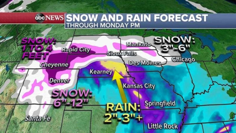
Locally, 1 to 4 feet of snow is expected in parts of the Rockies from this storm with a wide swath of 6 to 12 inches from Denver to Rapid City.
Locally, 3 to 6 inches of snow is expected in parts of the upper Midwest, with the highest totals expected in southern Minnesota.
Unfortunately, attention turns to another storm coming into the West and this one will go coast-to-coast with a wide range of impacts.
Some more rain and mountain snow is expected in the Western U.S. later Sunday and Monday and the snow in the mountains could cause dangerous travel, especially in the Sierra.
Then by Tuesday more snow will arrive in the Rockies which will just be coming out of the major storm they are receiving today.
It also looks like there will be an organized severe threat from the southern Plains to the Tennessee Valley beginning on Tuesday and Wednesday which could result in widespread damaging winds, large hail and more tornadoes.
Related Topics

Popular Reads
ABC News Live