Monsoon Rains Wreak Havoc on Roads Across the Southwest
Fires continues to burn in California.
— -- Despite its dry and desert-like reputation, the Southwest is no stranger to flash flooding. A week-long stretch of monsoonal moisture has brought torrential rainfall, mudslides, dust storms and dangerous lightning to the Desert Southwest.
Characterized by towering walls of blowing dust and dirt, a haboob can rapidly drop visibility to near zero in just minutes! The meteorological phenomenon is notorious for occurring during the monsoon season in the Four Corners region. These blinding dust storms can grow up to 10,000 feet high and typically occur only a few times per year in Arizona.
Flash flooding is typically a concern in slow-moving summertime thunderstorms. However, the terrain and geographical features of the Southwestern states only exacerbate the problem. Much of the heavy rainfall that comes out of ominous thunderstorms begins to run off rivers, down the mountains and out of creeks to quickly produce high-level rising waters. The unaccustomed and easily saturated grounds of the Western states have nowhere to store the excess water. Once the land reaches super-saturation, the water begins to build and rush down anything in its path: roadways, creeks, homes, lawns, and highways. All of these factors considered, states like Arizona, New Mexico, Utah, and Colorado are prone to the sweeping waters of flash flooding during the summer monsoon.
The powerhouse of a summertime monsoon is the sun. Fueled by uneven warming between the Pacific Ocean and the land, a battle erupts between shifting winds. As summer commences, the winds on the Pacific coast are typically westerly. As the sun becomes stronger into the summer months and rapidly heats the land, the winds attempt a reversal. The start of the Southwest Monsoon is marked by a 180-degree shift in wind direction from westerly to easterly.
The first thought that comes to many minds when monsoon season rolls around is “flooding”. However, the Southwest monsoon is a beneficiary as well. Daytime storms and cloud coverage help to alleviate some of the sweltering and oppressive heat that builds in the Desert Southwest during the summer months. The moisture it drags in helps to replenish rivers, lakes, and other water resources that are so desperate for rain year-round. Farmlands and vegetation are stimulated by a surplus of showers. Arizona and New Mexico receive up to half of their annual rainfall during the summer monsoon. On average, a typical summer monsoon will deliver 6 inches of rain to Tucson, and 3 inches of rain to Phoenix. In just the last week, a large chunk of Arizona picked up over 2 inches of rain, and some areas upwards of 3-4 inches of rain! With hourly rainfall rates and rainfall totals so unusually high, the environment doesn’t have enough time to adapt. When excessive rain falls relentlessly day after day, the parched grounds of the four corners region run out of storage and flash flooding becomes an inevitable threat.
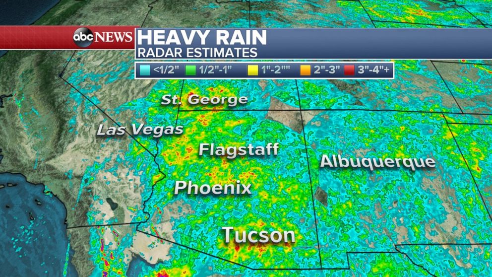
Over the last week the big picture in the Southwest has been frequent lightning, drenching rain, reduced visibility, high winds, and power outages. Wind gusts reached 89 mph in Gila Bend, Arizona, and up to 70 mph in Phoenix on Friday. Daily thunderstorms in Arizona, New Mexico, and Utah led to flash flooding which caused road closures on major highways including Interstate 17. Fortunate for Arizona, a drying pattern is forecast for late into the weekend and into next week. However, due to the incessant rain, swollen rivers, and super-saturated land, Flash Flood Watches still remain up for many states. Just this morning, Phoenix and Scottsdale saw major flash flooding: cars and trucks were left stranded, streets were closed, and fast-moving waters turned roadways into rivers. The Scottsdale Fire Department had to perform multiple water rescues on people trapped in cars along washed out roads in North Scottsdale. The valley area is expected to gradually dry out with hotter temperatures to crawl into Arizona Saturday and Sunday.
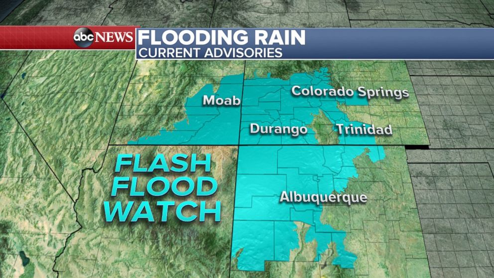
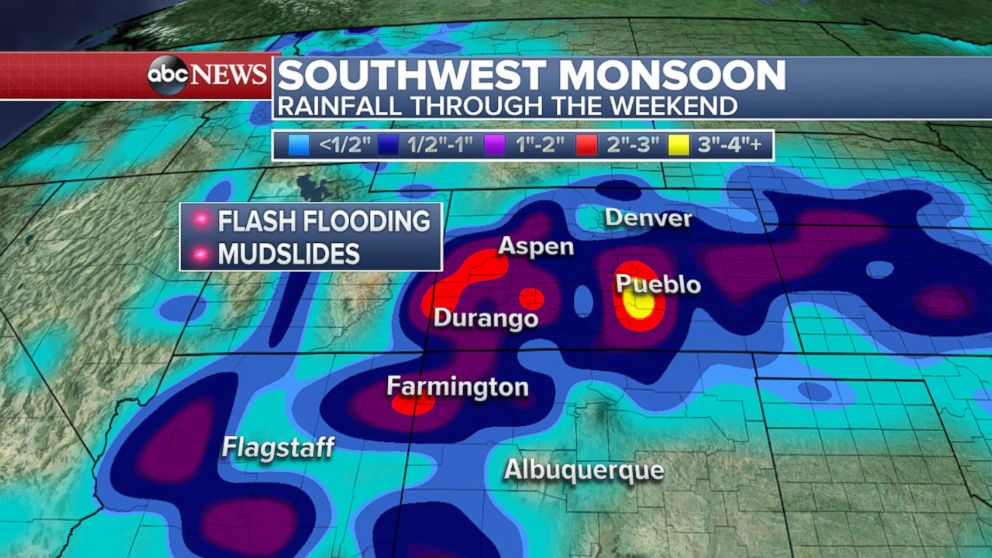
For the weekend, the monsoonal moisture is forecast to shift gears and push north and east out of Arizona. The combination of high temperatures and low humidity will cook the Valley area of Arizona on Saturday and Sunday, forcing the grounds to gradually dry. While boiling temperatures will parch the Valley, the mountainous terrain of Arizona can still see some thunderstorm development. Arizona will receive a few days of a much-needed break in the rain, but by Wednesday storm chances start to rise again. Now, It’s time to turn our attention to Colorado for the weekend forecast: soaking rain, mudslides, and flash flooding will be of concern. Aspen and Durango could be seeing over 2 inches of rain through Sunday and isolated batches of 3 inches or more in Pueblo can’t be ruled out.
Related Topics

Popular Reads
ABC News Live