Powerful storm to bring dangerous winds to Midwest, Northeast
Rain will soak the Northeast on Sunday, with gusty winds moving in behind.
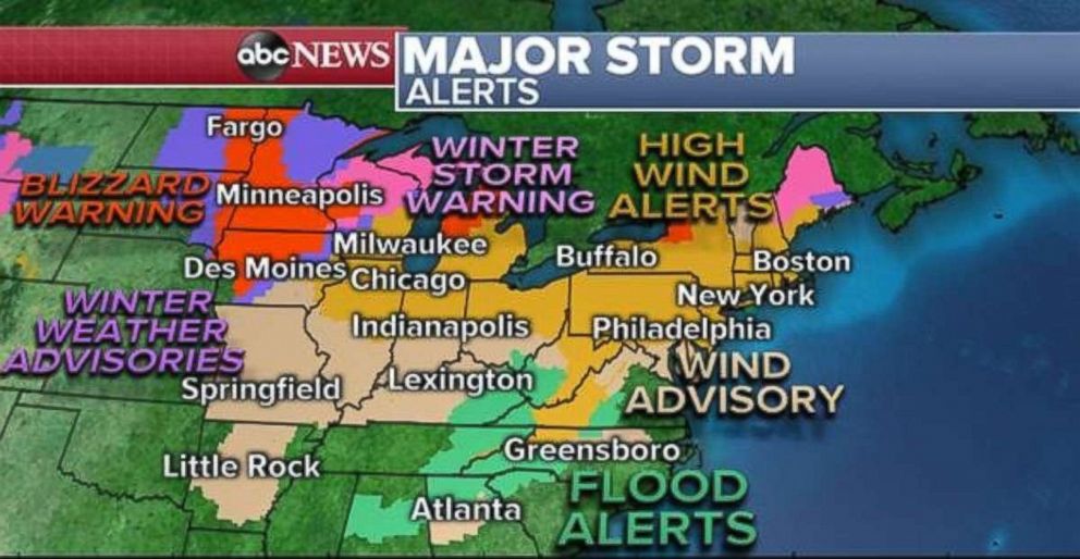
A powerful storm brought widespread dangerous weather to parts of the Midwest and South on Saturday, including severe weather and flash flooding in Mississippi and Tennessee and blizzard conditions from Kansas to Minnesota.
Four tornadoes were reported in the South, with one person killed in Columbus, Mississippi. The storm was also responsible for bringing 8 to 10 inches of rain locally across Mississippi and Tennessee. Des Moines, Iowa, has now seen its snowiest February on record, while Omaha, Nebraska, is tied for its snowiest with a few days left to go.
The storm is now moving through the Great Lakes and will track into southern Canada on Sunday, but the impacts are not over. The biggest impact moving forward will be the winds coming in behind the storm. Strong, gusty winds are moving into the Midwest Sunday morning, with wind gusts in Illinois and Missouri already reaching over 60 mph.
Meanwhile, heavy rain is moving up the East Coast and could cause some localized flash flooding in parts of the Northeast through the morning hours. Additionally, some of the precipitation is falling as freezing rain in parts of Connecticut, Massachusetts and New York. This could cause locally slippery travel Sunday morning.
Blizzard conditions will wind down in the Midwest later in the morning Sunday. The heaviest of the rain will fall on the East Coast, but here could be a couple of strong storms from Georgia to South Carolina.
There is still a very large area of the country -- nearly 150 million Americans from the Midwest to the Northeast -- that are under alerts from this dangerous storm. Wind alerts have been issued from parts of Arkansas all the way to Maine, including Chicago, Indianapolis, Philadelphia, New York and Boston.
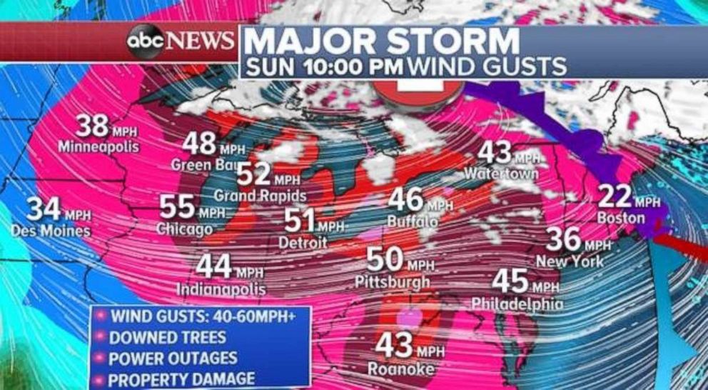
Wind gusts will reach over 50 mph in parts of the Midwest on Sunday morning. These strong winds will move into parts of the Great Lakes later Sunday and then eventually reach the Northeast by Sunday evening.
The combination of winds over 60 mph and lake effect snow could create dangerous whiteout conditions in western Michigan Sunday afternoon.
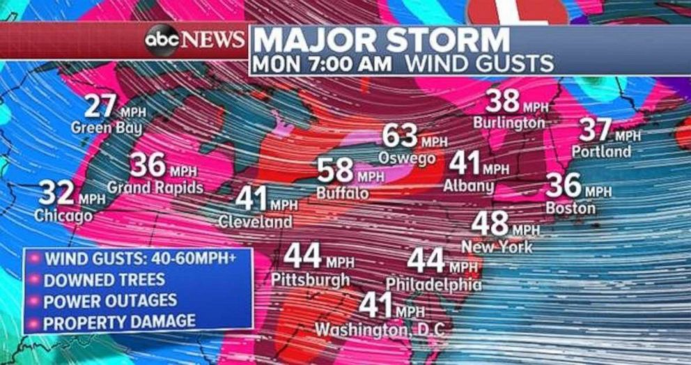
These powerful winds will impact the entire Northeast on Monday with winds gusting over 50 mph locally from Washington, D.C., to New York and Boston. Widespread wind gusts of 40 to 60 mph could cause downed trees, power outages and property damage -- even in the major cities.
Upstate New York, from Buffalo to Watertown, could see gusts up to 70 mph. With these powerful winds traveling over the Great Lakes, lake effect snow will develop from Oswego to Watertown. The snow combined with very high winds will create severe blowing snow with whiteout conditions and impossible travel.
Related Topics

Popular Reads
ABC News Live