Significant severe weather threatens central US; major warmup coming to East
Late-week temperatures across the Midwest and Northeast will be in the 80s.
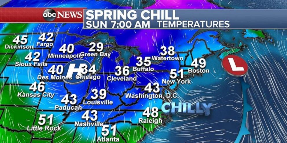
Much of the country is seeing a rather quiet weather weekend. In the wake of a frontal system, much of the Midwest and parts of the Northeast are seeing a chilly spring Sunday morning. Temperatures are in the 20s and 30s in parts of the Great Lakes and Ohio River valley.
However, the quiet weather will turn more turbulent this week as a system moving through the Northwest this morning heads toward the central U.S. in the coming days. The pattern change will bring several days of potentially significant severe weather in the central U.S. It will also spread spring warmth across nearly two-thirds of the nation from Texas to New England.
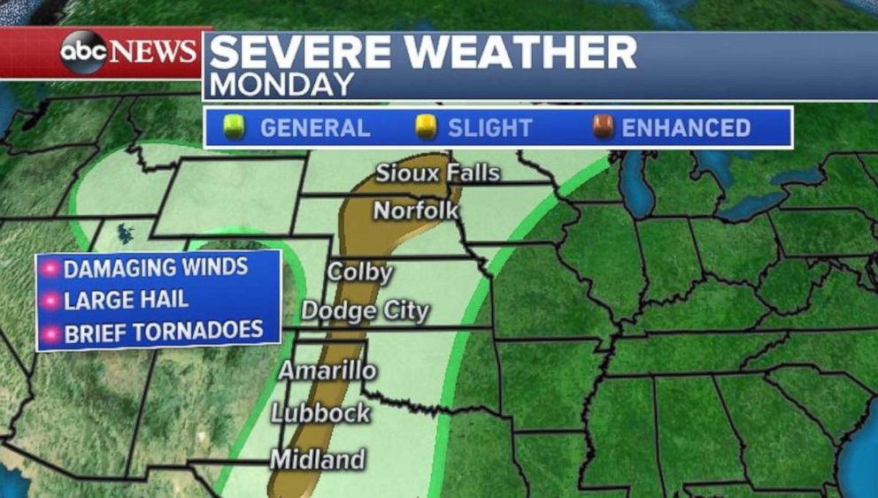
The weather pattern makes a multi-day severe weather event likely across the middle of the country. The first round of damaging winds, large hail and brief tornadoes comes on Monday from western Texas to southern South Dakota, including Dodge City, Sioux Falls and Amarillo.
On Tuesday, the activity moves into the Central Plains. An increased risk for severe weather is already being predicted for parts of Kansas, Nebraska, Iowa and Missouri. A slight risk for severe weather exists from Oklahoma to Iowa. While damaging winds and large hail are the main threat, tornadoes remain possible.
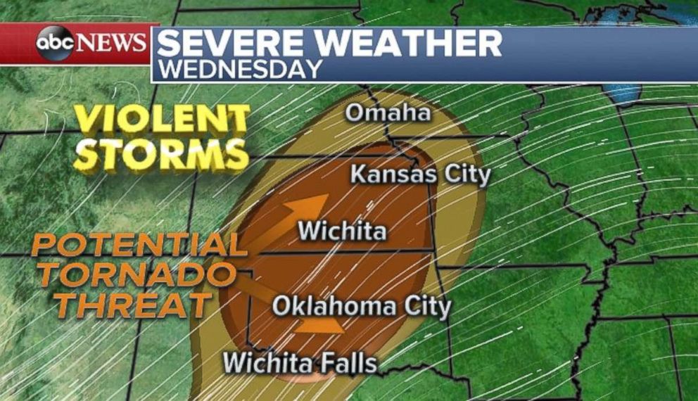
The potential for severe weather ramps up on Wednesday over much of Oklahoma and Kansas. Storms on Wednesday could be particularly strong, with a few tornadoes possible -- some of which could be strong. Oklahoma City; Wichita, Kansas; and the Kansas City metro areas are all at risk. While some details remain uncertain, it appears increasing likely that a significant tornado threat will exist in this region by midweek.
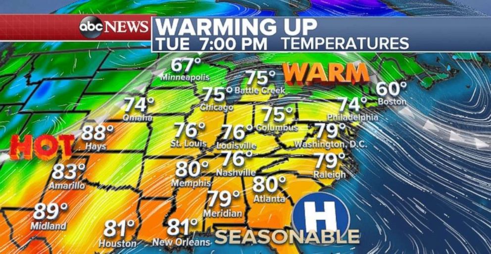
Temperatures rise above average
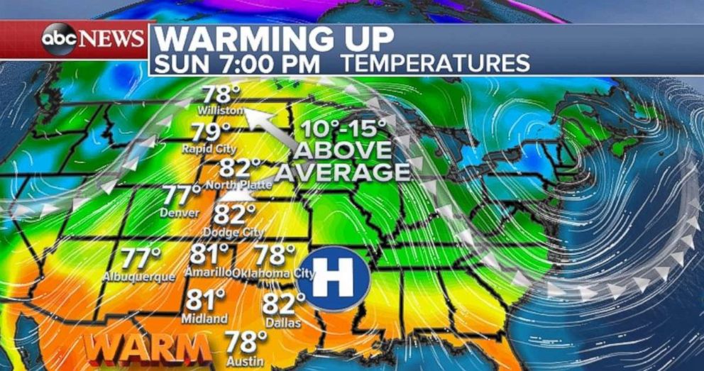
Meanwhile, ahead of the system, very warm air will surge northward all the way to the Canadian border. Temperatures are on the rise already on Sunday morning for the entire Northern Plains, with temperatures nearing 80 degrees or higher all the way to North Dakota. From Denver to North Platte, Nebraska to Rapid City, South Dakota, temperatures are nearly 10 to 15 degrees above average for this time of the year.
By Tuesday, the warm weather will cover nearly two-thirds of the country. Temperatures in parts of the Great Lakes, Midwest, and mid-Atlantic -- including Chicago, Detroit, Washington, D.C. and Philadelphia -- will be around 10 degrees above average. This will be the start of several warm days for the Northeast, with plenty of sunshine.
With the warmth building during the midweek, it will suddenly feel like summertime in the Northeast by Thursday and Friday. The temperatures could be almost 90 degrees for parts of the I-95 corridor. This is the warmest air mass much of this region has seen since August and September 2017.
High temperatures on both days will likely be nearly 20 degrees above average.
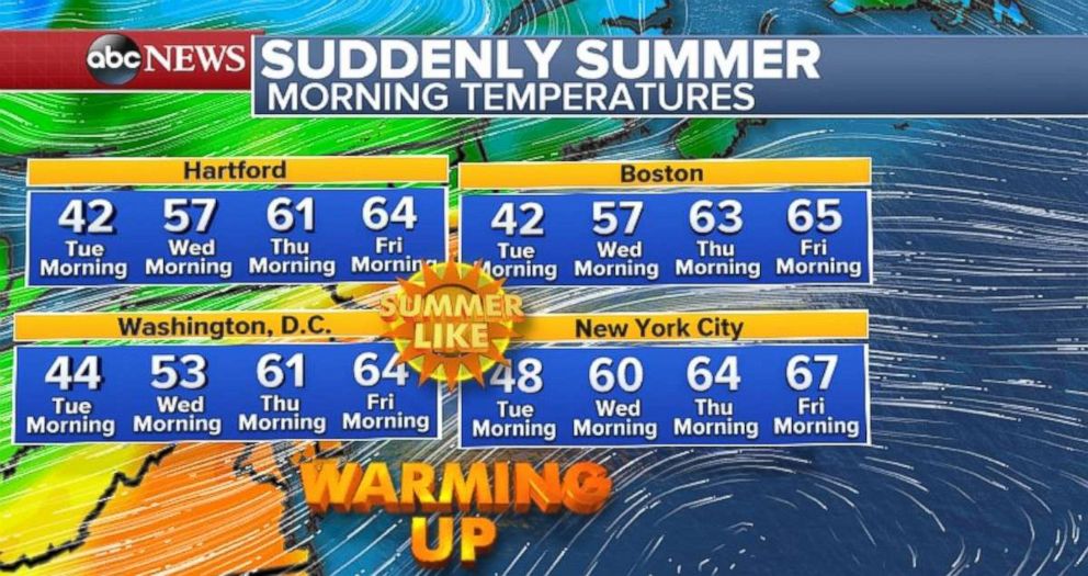
After weeks of dealing with cool weather, temperatures in the Northeast won't even drop below the typical afternoon average by the end of the week. Overnight lows in the mid- to upper-60s are likely by the end of the week.
Related Topics

Popular Reads

ABC News Live