East feels the chill; new storm hits Pacific Northwest adding to month of heavy rainfall
The warm-up is on the way quickly behind the current cold in the East.
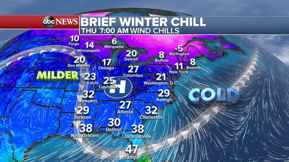
— -- A blast of cold weather on Thursday is reminding people in the Northeast that it is still the dead of winter.
After temperatures near 60 degrees earlier this week, it is feeling like the teens and single-digits across the Northeast Thursday morning. The colder air is making it all the way down to Florida with wind chills in the 30s in Jacksonville.
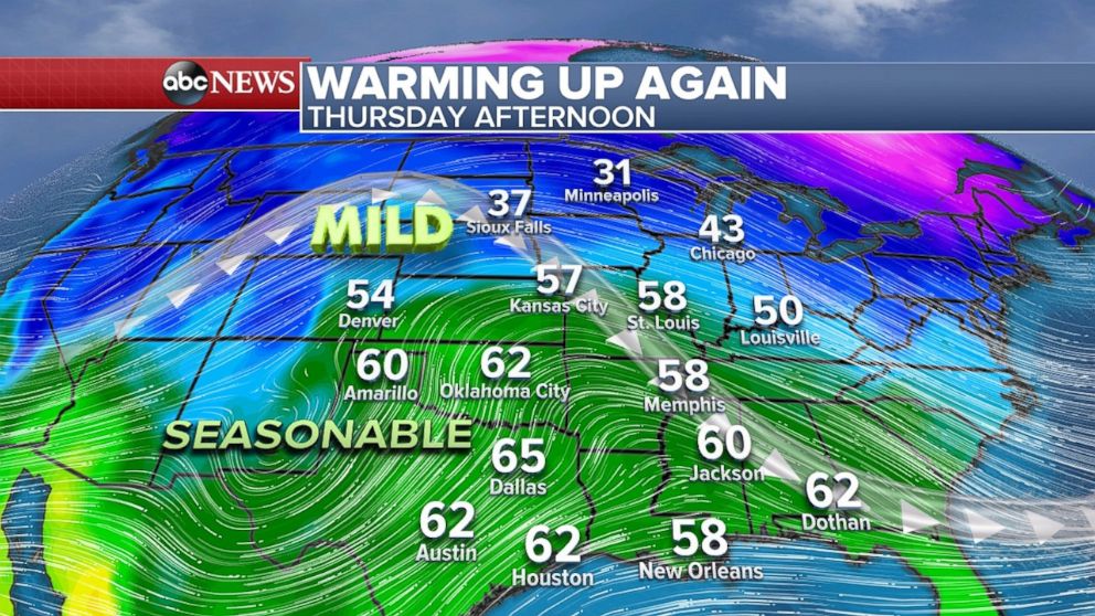
The good news is there is already a mild trend building in the central U.S. which will spread eastward over the next few days.
Temperatures on Thursday afternoon in parts of the Central Plains and Midwest will rise 5 to 15 degrees above average. Temperatures are in the 40s and 50s from Kansas to Illinois. After receiving a blizzard earlier this week, temperatures are in the 30s from Nebraska to Minnesota.
This milder weather will spread east the next few days, with temperatures nearing 60 degrees in Philadelphia and Washington, D.C on Saturday. It will be in the 50s this weekend in New York City. These temperatures are 10 to 20 degrees above average for this time of the year.
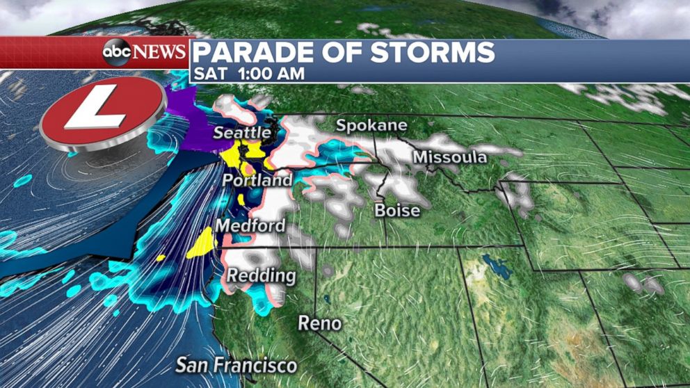
Northwest expecting more rain
A western storm brought more heavy rain and mountain snow on Wednesday -- the latest in a line of storms that has brought rain to the region 20 of the past 21 days in Seattle. And there is no break in sight for the next few days at least.
There is another storm lurking in the Pacific Ocean due to arrive in the Northwest this weekend. This storm will have a little bit of a tropical connection and bring a good deal of rain to the Northwest coastline.
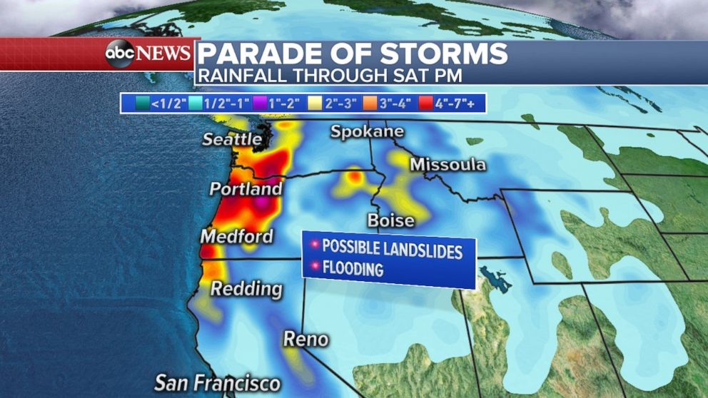
Several inches of rain are possible along the coastline. This region of the country is prone to deluges during winter and therefore flooding should remain rather limited.
However, flooding will be possible this weekend in northwest Oregon and southwest Washington. Rivers are beginning to run high from rain this week and soil is now saturated. In the Olympic Mountains, nearly a foot of rain is possible, which could also start to flood rivers out of its banks. With a forecast for more than 5 inches of rain in spots along the coast and parts of the Cascades, there is growing concern for additional river flooding, and possible landslides.
Warmth on the way next week
Outside of the Northwest storms, much of the country is rather quiet, considering this is typically a turbulent time of the year.
Over the weekend there will be a cold front that will develop across the central U.S., bringing rain to parts of the Mississippi and Ohio River valleys. Some of this rain could potentially be heavy along the Gulf Coast of Florida.
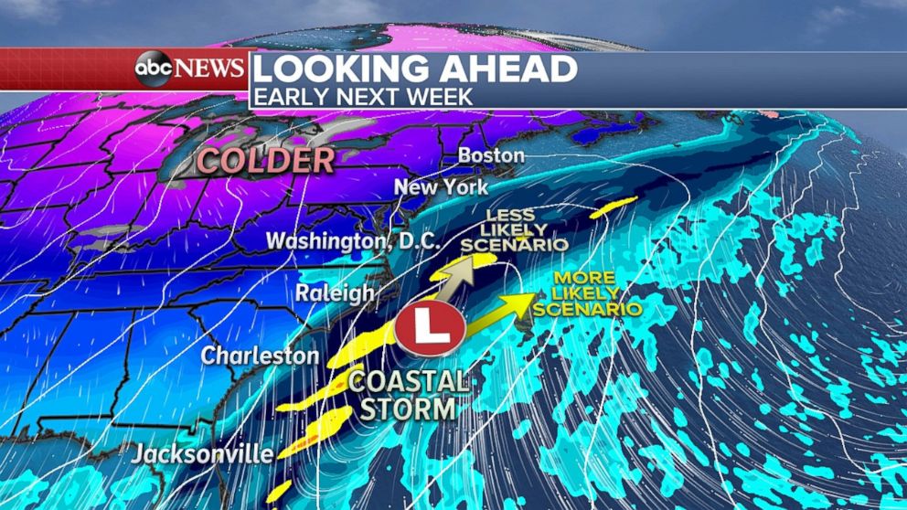
Early next week a coastal system could develop near the East Coast of the U.S. Luckily, right now forecast models are favoring a solution that would keep this system far enough from the U.S. to spare the coastline from notable impacts. Due to this potential event being several days away, this forecast will likely continue to evolve and change over the next few days.
Related Topics

Popular Reads
ABC News Live