Heat Wave Sweeps US; NOAA Says Spring Flood Risk Low

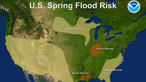
U.S. Spring Flood Risk Map for 2012. Image: NOAA
ABC News' Alexa Keyes reports:
For the first time in four years, there is no major flood risk warning in effect for any part of the United States, according to NOAA's annual Spring Outlook.
"The U.S. is getting a much needed spring break," said Laura Furgione, deputy director of the National Weather Service, part of the National Oceanographic and Atmospheric Administration. "What a difference a year makes."
Spring officially begins next Tuesday, and is proving to be very different from the record spring flooding the country saw in 2011. Most of the country is at normal or below-normal risk for floods this year, according to NOAA's forecast of the flood potential from April to June.
Last year, almost half the country had an above average risk of flooding," Furgione said at NOAA's teleconference this afternoon. "That is a stark contrast to this year."
The only areas with above-normal flood risks are the Ohio River Valley and parts of the Gulf Coast, though Furgione said, "Heavy rainfall can lead to flooding at any time."
Forecasters say drought conditions will persist through spring across the southern and southwestern parts of the U.S.
"This is the fifty-first consecutive week where at least two-thirds of Texas have been at risk for severe, extreme or exceptional drought," said David Brown, director of Southern Region Climate Services.
As the peak of wildfire season approaches, drought conditions are concerning for parts of the country that sustained heavy losses last year, particularly Texas, New Mexico and Oklahoma. But drought situations have also emerged in the Southeast. More than three-fourths of the state of Georgia are also facing severe drought conditions. If the droughts persist, Brown said, it could result in an active wildfire season.
NOAA summed up the 2012 drought situation at the teleconference as "more less severe droughts [compared to 2011], but less more extreme droughts."
Another hot topic right now is the rising heat index across the country. The famous cherry blossoms in the nation's capital will be in peak bloom more than two weeks ahead of schedule this year, and farmers around the country are gearing up for the unseasonably warm temperatures. On Wednesday alone, 400 new record highs were recorded, in addition to 177 low temperatures that were warmer than any on record for those locations on a March 14. That made for a total of 577 new warmth records from Florida to Wisconsin.
NOAA managers said they cannot say for certain if the rising heat index is connected to global climate change.
"Extreme events like the ones that we're seeing are consistent with the notion that the climate is changing towards warmer, and obviously when records are broken that's an unprecedented event, but without a lot of research and study it's impossible to connect any single event with climate change," said Ed O'Lenic, chief of the operations branch at NOAA's Climate Prediction Center.
The monthly forecast calls for a continuation of above-normal temperatures for at least the rest of the month, and the Southwest, South and Eastern United States should prepare for an even hotter summer.
After a long season of not-quite fall, not-quite winter weather, it's official - for now, the warm weather is here to stay.