Google Creates Virtual Record of Tsunami Wreckage
TOKYO - In the early hours after the tsunami hit northeast Japan last year, Google launched a Person Finder site that helped reconnect families and loved ones in the most devastated regions.
Months later, the web giant dispatched its street view cars - 15 cameras mounted on each - to document the disaster zone in 360-degree view.
Nearly two years later, Google is harnessing its technology once again to launch a unique digital archive project that gives users a virtual tour of buildings damaged by the waves.
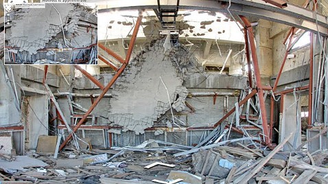
The "Memories for the Future" site utilizes technology behind Google Business Photos, typically used by restaurants and retail stores to give customers an interactive tour. This time it is being used to document more than 30 buildings in the coastal cities of Rikuzentakata, Kamaishi, Ofunato and Namie. The panoramic images allow users to walk through a gutted city office, where smashed cars still remain, surrounded by scraps of metal and wood.
Inside a Namie elementary school, just miles from the Fukushima Daiichi power plant, a graduation banner still hangs in a gym, the floors are cracked. A view from the third floor balcony shows how little remains around the building now.
"We have been trying to find ways using the power of technology to help communities recover and help them tell stories," said Kei Kawai, product manager at Google. "Our hope is that we can provide tools to let other people know what it's like to be in the region now."
The idea for the project came last month as city leaders debated the fate of their most devastated buildings. Many residents had called for preservation, arguing the structures should prove as a constant reminder of the tragedy, while others pushed to tear them down, advocating a new start.
Kawai said most buildings documented so far were set to be demolished in a few months, so Google had to act quickly. With the help of government officials, employees were given access to take photos inside the structures, including those in the restricted nuclear zone.
They captured more than three dozen buildings in a few weeks.
Google has used its technology to document natural disasters in the past. Street View captured flooded streets in New Orleans after Hurricane Katrina, and Person Finder was launched after the earthquake in Haiti. But this is the first time the company has combined its Street View and Business Photos features to chronicle devastation on such a wide scale.
Kawai hopes to add five additional cities to the project by the end of the year and says the Japan site could serve as an example of how Google responds to future disasters.
"We are still creating a template on how to assist in longer term recovery," he said. "How to assist in keeping the record, and archiving the memories of the region."